You are here: Home > Network List > TA - USArray Transportable Network (new EarthScope stations) Stations List
> Station K27A Flueckinger Farm, Gordon, NE, USA > Earthquake Result Viewer
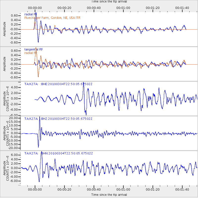
K27A Flueckinger Farm, Gordon, NE, USA - Earthquake Result Viewer

| Earthquake location: |
Northern Chile |
| Earthquake latitude/longitude: |
-22.2/-68.3 |
| Earthquake time(UTC): |
2010/03/04 (063) 22:39:26 GMT |
| Earthquake Depth: |
114 km |
| Earthquake Magnitude: |
6.3 MB, 6.4 MW, 6.3 MW |
| Earthquake Catalog/Contributor: |
WHDF/NEIC |
|
| Network: |
TA USArray Transportable Network (new EarthScope stations) |
| Station: |
K27A Flueckinger Farm, Gordon, NE, USA |
| Lat/Lon: |
42.70 N/102.24 W |
| Elevation: |
1131 m |
|
| Distance: |
71.8 deg |
| Az: |
334.346 deg |
| Baz: |
147.03 deg |
| Ray Param: |
0.053813286 |
| Estimated Moho Depth: |
12.25 km |
| Estimated Crust Vp/Vs: |
1.60 |
| Assumed Crust Vp: |
6.483 km/s |
| Estimated Crust Vs: |
4.052 km/s |
| Estimated Crust Poisson's Ratio: |
0.18 |
|
| Radial Match: |
84.15845 % |
| Radial Bump: |
373 |
| Transverse Match: |
87.961876 % |
| Transverse Bump: |
358 |
| SOD ConfigId: |
308276 |
| Insert Time: |
2010-06-22 16:54:38.957 +0000 |
| GWidth: |
2.5 |
| Max Bumps: |
400 |
| Tol: |
0.001 |
|
Signal To Noise
| Channel | StoN | STA | LTA |
| TA:K27A: :BHZ:20100304T22:50:05.67502Z | 28.242468 | 8.332184E-6 | 2.9502323E-7 |
| TA:K27A: :BHN:20100304T22:50:05.67502Z | 6.559827 | 3.6943077E-6 | 5.631715E-7 |
| TA:K27A: :BHE:20100304T22:50:05.67502Z | 3.8944042 | 2.8505722E-6 | 7.319662E-7 |
| Arrivals |
| Ps | 1.2 SECOND |
| PpPs | 4.7 SECOND |
| PsPs/PpSs | 5.9 SECOND |


