You are here: Home > Network List > JP - Japan Meteorological Agency Seismic Network Stations List
> Station YOJ Yonagunijima Island > Earthquake Result Viewer
YOJ Yonagunijima Island - Earthquake Result Viewer
| Earthquake location: |
Kermadec Islands Region |
| Earthquake latitude/longitude: |
-30.4/-176.7 |
| Earthquake time(UTC): |
2023/04/24 (114) 00:41:46 GMT |
| Earthquake Depth: |
10 km |
| Earthquake Magnitude: |
7.3 Mi |
| Earthquake Catalog/Contributor: |
NEIC PDE/pt |
|
| Network: |
JP Japan Meteorological Agency Seismic Network |
| Station: |
YOJ Yonagunijima Island |
| Lat/Lon: |
24.47 N/123.01 E |
| Elevation: |
32 m |
|
| Distance: |
79.5 deg |
| Az: |
306.402 deg |
| Baz: |
130.267 deg |
| Ray Param: |
0.048952032 |
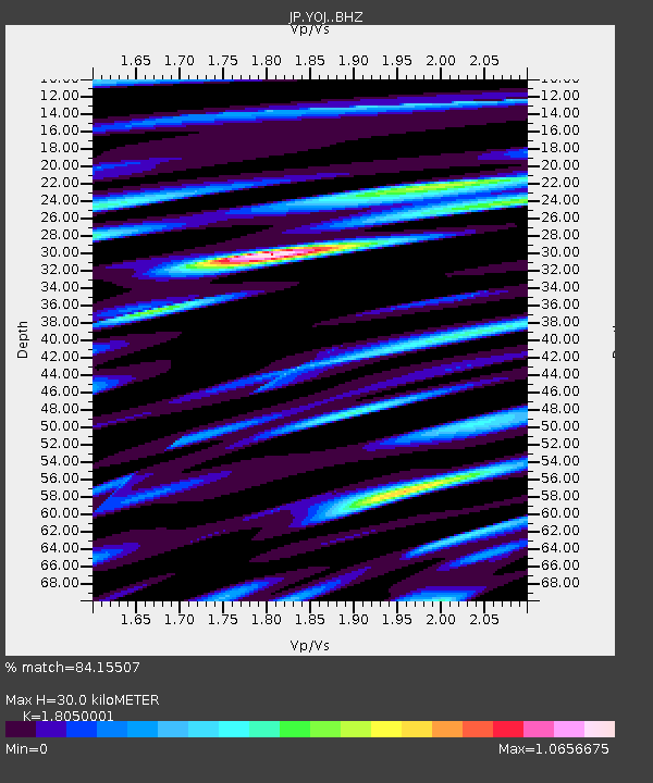
| Estimated Moho Depth: |
30.0 km |
| Estimated Crust Vp/Vs: |
1.81 |
| Assumed Crust Vp: |
6.183 km/s |
| Estimated Crust Vs: |
3.425 km/s |
| Estimated Crust Poisson's Ratio: |
0.28 |
|
| Radial Match: |
84.15507 % |
| Radial Bump: |
400 |
| Transverse Match: |
75.47176 % |
| Transverse Bump: |
400 |
| SOD ConfigId: |
30536071 |
| Insert Time: |
2023-05-08 00:53:25.206 +0000 |
| GWidth: |
2.5 |
| Max Bumps: |
400 |
| Tol: |
0.001 |
|

Signal To Noise
| Channel | StoN | STA | LTA |
| JP:YOJ: :BHZ:20230424T00:53:21.099976Z | 11.816453 | 7.6174415E-6 | 6.4464706E-7 |
| JP:YOJ: :BHN:20230424T00:53:21.099976Z | 2.8772047 | 1.7051974E-6 | 5.9265767E-7 |
| JP:YOJ: :BHE:20230424T00:53:21.099976Z | 3.2408717 | 2.0298953E-6 | 6.2634234E-7 |
| Arrivals |
| Ps | 4.0 SECOND |
| PpPs | 13 SECOND |
| PsPs/PpSs | 17 SECOND |


