You are here: Home > Network List > TA - USArray Transportable Network (new EarthScope stations) Stations List
> Station T27A Campo, CO, USA > Earthquake Result Viewer
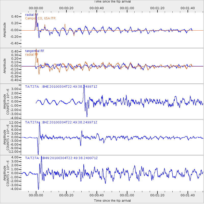
T27A Campo, CO, USA - Earthquake Result Viewer
*The percent match for this event was below the threshold and hence no stack was calculated.
| Earthquake location: |
Northern Chile |
| Earthquake latitude/longitude: |
-22.2/-68.3 |
| Earthquake time(UTC): |
2010/03/04 (063) 22:39:26 GMT |
| Earthquake Depth: |
114 km |
| Earthquake Magnitude: |
6.3 MB, 6.4 MW, 6.3 MW |
| Earthquake Catalog/Contributor: |
WHDF/NEIC |
|
| Network: |
TA USArray Transportable Network (new EarthScope stations) |
| Station: |
T27A Campo, CO, USA |
| Lat/Lon: |
37.06 N/102.72 W |
| Elevation: |
1366 m |
|
| Distance: |
67.3 deg |
| Az: |
330.672 deg |
| Baz: |
145.434 deg |
| Ray Param: |
$rayparam |
*The percent match for this event was below the threshold and hence was not used in the summary stack. |
|
| Radial Match: |
79.765175 % |
| Radial Bump: |
398 |
| Transverse Match: |
70.81316 % |
| Transverse Bump: |
400 |
| SOD ConfigId: |
308276 |
| Insert Time: |
2010-06-22 16:56:32.361 +0000 |
| GWidth: |
2.5 |
| Max Bumps: |
400 |
| Tol: |
0.001 |
|
Signal To Noise
| Channel | StoN | STA | LTA |
| TA:T27A: :BHZ:20100304T22:49:38.249971Z | 15.88741 | 5.329222E-6 | 3.354368E-7 |
| TA:T27A: :BHN:20100304T22:49:38.249971Z | 6.146073 | 1.8683012E-6 | 3.0398292E-7 |
| TA:T27A: :BHE:20100304T22:49:38.249971Z | 4.757226 | 1.7655522E-6 | 3.711306E-7 |
| Arrivals |
| Ps | |
| PpPs | |
| PsPs/PpSs | |


