You are here: Home > Network List > AK - Alaska Regional Network Stations List
> Station KTH Kantishna Hills > Earthquake Result Viewer
KTH Kantishna Hills - Earthquake Result Viewer
| Earthquake location: |
Kermadec Islands, New Zealand |
| Earthquake latitude/longitude: |
-30.0/-177.9 |
| Earthquake time(UTC): |
2023/04/24 (114) 00:41:54 GMT |
| Earthquake Depth: |
34 km |
| Earthquake Magnitude: |
7.3 mww |
| Earthquake Catalog/Contributor: |
NEIC PDE/us |
|
| Network: |
AK Alaska Regional Network |
| Station: |
KTH Kantishna Hills |
| Lat/Lon: |
63.55 N/150.92 W |
| Elevation: |
1172 m |
|
| Distance: |
95.7 deg |
| Az: |
11.778 deg |
| Baz: |
203.288 deg |
| Ray Param: |
0.04071142 |
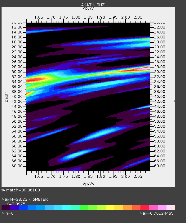
| Estimated Moho Depth: |
28.25 km |
| Estimated Crust Vp/Vs: |
2.10 |
| Assumed Crust Vp: |
6.438 km/s |
| Estimated Crust Vs: |
3.069 km/s |
| Estimated Crust Poisson's Ratio: |
0.35 |
|
| Radial Match: |
89.86183 % |
| Radial Bump: |
400 |
| Transverse Match: |
70.03636 % |
| Transverse Bump: |
400 |
| SOD ConfigId: |
30536071 |
| Insert Time: |
2023-05-08 01:03:20.236 +0000 |
| GWidth: |
2.5 |
| Max Bumps: |
400 |
| Tol: |
0.001 |
|

Signal To Noise
| Channel | StoN | STA | LTA |
| AK:KTH: :BHZ:20230424T00:54:45.808023Z | 17.797384 | 2.558686E-6 | 1.4376752E-7 |
| AK:KTH: :BHN:20230424T00:54:45.808023Z | 3.8513348 | 9.2328975E-7 | 2.397324E-7 |
| AK:KTH: :BHE:20230424T00:54:45.808023Z | 5.3975444 | 6.763899E-7 | 1.2531437E-7 |
| Arrivals |
| Ps | 4.9 SECOND |
| PpPs | 13 SECOND |
| PsPs/PpSs | 18 SECOND |


