You are here: Home > Network List > AK - Alaska Regional Network Stations List
> Station NEA2 Nenana, AK, USA > Earthquake Result Viewer
NEA2 Nenana, AK, USA - Earthquake Result Viewer
| Earthquake location: |
Kermadec Islands, New Zealand |
| Earthquake latitude/longitude: |
-30.0/-177.9 |
| Earthquake time(UTC): |
2023/04/24 (114) 00:41:54 GMT |
| Earthquake Depth: |
34 km |
| Earthquake Magnitude: |
7.3 mww |
| Earthquake Catalog/Contributor: |
NEIC PDE/us |
|
| Network: |
AK Alaska Regional Network |
| Station: |
NEA2 Nenana, AK, USA |
| Lat/Lon: |
64.59 N/149.07 W |
| Elevation: |
450 m |
|
| Distance: |
97.0 deg |
| Az: |
12.097 deg |
| Baz: |
204.916 deg |
| Ray Param: |
0.04034302 |
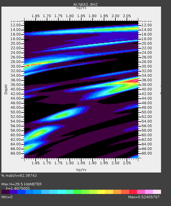
| Estimated Moho Depth: |
29.5 km |
| Estimated Crust Vp/Vs: |
1.61 |
| Assumed Crust Vp: |
6.566 km/s |
| Estimated Crust Vs: |
4.085 km/s |
| Estimated Crust Poisson's Ratio: |
0.18 |
|
| Radial Match: |
92.39743 % |
| Radial Bump: |
296 |
| Transverse Match: |
65.19193 % |
| Transverse Bump: |
400 |
| SOD ConfigId: |
30536071 |
| Insert Time: |
2023-05-08 01:03:47.299 +0000 |
| GWidth: |
2.5 |
| Max Bumps: |
400 |
| Tol: |
0.001 |
|

Signal To Noise
| Channel | StoN | STA | LTA |
| AK:NEA2: :BHZ:20230424T00:54:51.587992Z | 19.292713 | 2.2714753E-6 | 1.1773748E-7 |
| AK:NEA2: :BHN:20230424T00:54:51.587992Z | 4.032619 | 7.070484E-7 | 1.753323E-7 |
| AK:NEA2: :BHE:20230424T00:54:51.587992Z | 2.0484636 | 4.6302745E-7 | 2.2603645E-7 |
| Arrivals |
| Ps | 2.8 SECOND |
| PpPs | 11 SECOND |
| PsPs/PpSs | 14 SECOND |


