You are here: Home > Network List > TA - USArray Transportable Network (new EarthScope stations) Stations List
> Station 228A UT Block 9, Goldsmith, TX, USA > Earthquake Result Viewer
228A UT Block 9, Goldsmith, TX, USA - Earthquake Result Viewer
| Earthquake location: |
Northern Chile |
| Earthquake latitude/longitude: |
-22.2/-68.3 |
| Earthquake time(UTC): |
2010/03/04 (063) 22:39:26 GMT |
| Earthquake Depth: |
114 km |
| Earthquake Magnitude: |
6.3 MB, 6.4 MW, 6.3 MW |
| Earthquake Catalog/Contributor: |
WHDF/NEIC |
|
| Network: |
TA USArray Transportable Network (new EarthScope stations) |
| Station: |
228A UT Block 9, Goldsmith, TX, USA |
| Lat/Lon: |
32.12 N/102.59 W |
| Elevation: |
954 m |
|
| Distance: |
63.2 deg |
| Az: |
327.642 deg |
| Baz: |
144.238 deg |
| Ray Param: |
0.059412472 |
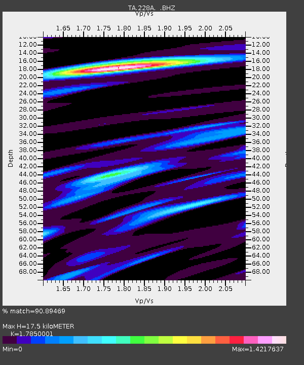
| Estimated Moho Depth: |
17.5 km |
| Estimated Crust Vp/Vs: |
1.79 |
| Assumed Crust Vp: |
6.129 km/s |
| Estimated Crust Vs: |
3.434 km/s |
| Estimated Crust Poisson's Ratio: |
0.27 |
|
| Radial Match: |
90.89469 % |
| Radial Bump: |
400 |
| Transverse Match: |
81.729836 % |
| Transverse Bump: |
400 |
| SOD ConfigId: |
308276 |
| Insert Time: |
2010-06-22 16:58:11.567 +0000 |
| GWidth: |
2.5 |
| Max Bumps: |
400 |
| Tol: |
0.001 |
|

Signal To Noise
| Channel | StoN | STA | LTA |
| TA:228A: :BHZ:20100304T22:49:11.899995Z | 29.486372 | 4.626198E-6 | 1.5689274E-7 |
| TA:228A: :BHN:20100304T22:49:11.899995Z | 11.680509 | 2.3163284E-6 | 1.9830716E-7 |
| TA:228A: :BHE:20100304T22:49:11.899995Z | 6.8152246 | 1.4170525E-6 | 2.0792456E-7 |
| Arrivals |
| Ps | 2.3 SECOND |
| PpPs | 7.6 SECOND |
| PsPs/PpSs | 10.0 SECOND |


