You are here: Home > Network List > US - United States National Seismic Network Stations List
> Station EGMT Eagleton, Montana, USA > Earthquake Result Viewer
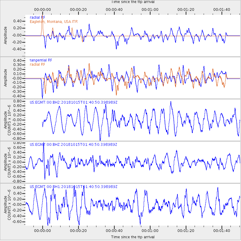
EGMT Eagleton, Montana, USA - Earthquake Result Viewer
*The percent match for this event was below the threshold and hence no stack was calculated.
| Earthquake location: |
Near East Coast Of Kamchatka |
| Earthquake latitude/longitude: |
54.1/159.5 |
| Earthquake time(UTC): |
2018/10/15 (288) 01:32:12 GMT |
| Earthquake Depth: |
124 km |
| Earthquake Magnitude: |
5.6 mb |
| Earthquake Catalog/Contributor: |
NEIC PDE/us |
|
| Network: |
US United States National Seismic Network |
| Station: |
EGMT Eagleton, Montana, USA |
| Lat/Lon: |
48.02 N/109.75 W |
| Elevation: |
1055 m |
|
| Distance: |
53.6 deg |
| Az: |
56.498 deg |
| Baz: |
312.929 deg |
| Ray Param: |
$rayparam |
*The percent match for this event was below the threshold and hence was not used in the summary stack. |
|
| Radial Match: |
43.17525 % |
| Radial Bump: |
366 |
| Transverse Match: |
47.668884 % |
| Transverse Bump: |
400 |
| SOD ConfigId: |
3045211 |
| Insert Time: |
2018-10-29 01:42:23.530 +0000 |
| GWidth: |
2.5 |
| Max Bumps: |
400 |
| Tol: |
0.001 |
|
Signal To Noise
| Channel | StoN | STA | LTA |
| US:EGMT:00:BHZ:20181015T01:40:50.398989Z | 1.7167795 | 3.498165E-7 | 2.0376322E-7 |
| US:EGMT:00:BH1:20181015T01:40:50.398989Z | 2.2304869 | 4.1492046E-7 | 1.8602239E-7 |
| US:EGMT:00:BH2:20181015T01:40:50.398989Z | 1.2964371 | 4.3118794E-7 | 3.3259457E-7 |
| Arrivals |
| Ps | |
| PpPs | |
| PsPs/PpSs | |


