You are here: Home > Network List > AV - Alaska Volcano Observatory Stations List
> Station SPCG Capps Glacier, Mount Spurr, Alaska > Earthquake Result Viewer
SPCG Capps Glacier, Mount Spurr, Alaska - Earthquake Result Viewer
| Earthquake location: |
Kermadec Islands, New Zealand |
| Earthquake latitude/longitude: |
-30.0/-177.9 |
| Earthquake time(UTC): |
2023/04/24 (114) 00:41:54 GMT |
| Earthquake Depth: |
34 km |
| Earthquake Magnitude: |
7.3 mww |
| Earthquake Catalog/Contributor: |
NEIC PDE/us |
|
| Network: |
AV Alaska Volcano Observatory |
| Station: |
SPCG Capps Glacier, Mount Spurr, Alaska |
| Lat/Lon: |
61.29 N/152.02 W |
| Elevation: |
1329 m |
|
| Distance: |
93.4 deg |
| Az: |
12.187 deg |
| Baz: |
202.282 deg |
| Ray Param: |
0.041264925 |
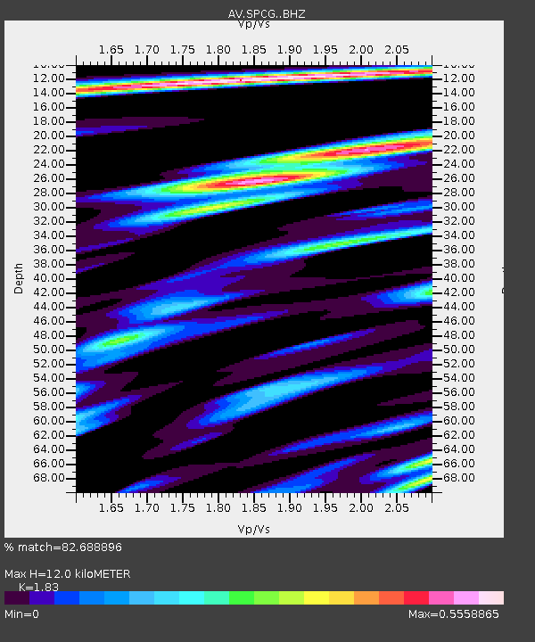
| Estimated Moho Depth: |
12.0 km |
| Estimated Crust Vp/Vs: |
1.83 |
| Assumed Crust Vp: |
6.566 km/s |
| Estimated Crust Vs: |
3.588 km/s |
| Estimated Crust Poisson's Ratio: |
0.29 |
|
| Radial Match: |
82.688896 % |
| Radial Bump: |
400 |
| Transverse Match: |
76.45863 % |
| Transverse Bump: |
400 |
| SOD ConfigId: |
30536071 |
| Insert Time: |
2023-05-08 01:09:26.778 +0000 |
| GWidth: |
2.5 |
| Max Bumps: |
400 |
| Tol: |
0.001 |
|

Signal To Noise
| Channel | StoN | STA | LTA |
| AV:SPCG: :BHZ:20230424T00:54:35.379007Z | 10.964244 | 3.0954513E-6 | 2.8232236E-7 |
| AV:SPCG: :BHN:20230424T00:54:35.379007Z | 2.889855 | 1.1949214E-6 | 4.1348838E-7 |
| AV:SPCG: :BHE:20230424T00:54:35.379007Z | 2.50879 | 6.407879E-7 | 2.5541712E-7 |
| Arrivals |
| Ps | 1.5 SECOND |
| PpPs | 5.1 SECOND |
| PsPs/PpSs | 6.6 SECOND |


