You are here: Home > Network List > AV - Alaska Volcano Observatory Stations List
> Station SPCL Chakachamna Lake, Mount Spurr, Alaska > Earthquake Result Viewer
SPCL Chakachamna Lake, Mount Spurr, Alaska - Earthquake Result Viewer
| Earthquake location: |
Kermadec Islands, New Zealand |
| Earthquake latitude/longitude: |
-30.0/-177.9 |
| Earthquake time(UTC): |
2023/04/24 (114) 00:41:54 GMT |
| Earthquake Depth: |
34 km |
| Earthquake Magnitude: |
7.3 mww |
| Earthquake Catalog/Contributor: |
NEIC PDE/us |
|
| Network: |
AV Alaska Volcano Observatory |
| Station: |
SPCL Chakachamna Lake, Mount Spurr, Alaska |
| Lat/Lon: |
61.20 N/152.34 W |
| Elevation: |
1274 m |
|
| Distance: |
93.2 deg |
| Az: |
12.08 deg |
| Baz: |
202.009 deg |
| Ray Param: |
0.04129546 |
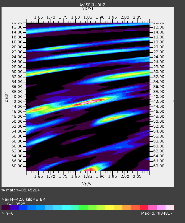
| Estimated Moho Depth: |
42.0 km |
| Estimated Crust Vp/Vs: |
1.85 |
| Assumed Crust Vp: |
6.566 km/s |
| Estimated Crust Vs: |
3.544 km/s |
| Estimated Crust Poisson's Ratio: |
0.29 |
|
| Radial Match: |
85.45204 % |
| Radial Bump: |
400 |
| Transverse Match: |
76.85067 % |
| Transverse Bump: |
400 |
| SOD ConfigId: |
30536071 |
| Insert Time: |
2023-05-08 01:09:27.394 +0000 |
| GWidth: |
2.5 |
| Max Bumps: |
400 |
| Tol: |
0.001 |
|

Signal To Noise
| Channel | StoN | STA | LTA |
| AV:SPCL: :BHZ:20230424T00:54:34.699991Z | 15.152725 | 3.085255E-6 | 2.0361057E-7 |
| AV:SPCL: :BHN:20230424T00:54:34.699991Z | 3.1453447 | 1.0081768E-6 | 3.205298E-7 |
| AV:SPCL: :BHE:20230424T00:54:34.699991Z | 1.5798684 | 6.4192244E-7 | 4.0631386E-7 |
| Arrivals |
| Ps | 5.6 SECOND |
| PpPs | 18 SECOND |
| PsPs/PpSs | 23 SECOND |


