You are here: Home > Network List > C0 - Colorado Geological Survey Seismic Network Stations List
> Station N23A Red Feather Lakes, CO > Earthquake Result Viewer
N23A Red Feather Lakes, CO - Earthquake Result Viewer
| Earthquake location: |
Kermadec Islands, New Zealand |
| Earthquake latitude/longitude: |
-30.0/-177.9 |
| Earthquake time(UTC): |
2023/04/24 (114) 00:41:54 GMT |
| Earthquake Depth: |
34 km |
| Earthquake Magnitude: |
7.3 mww |
| Earthquake Catalog/Contributor: |
NEIC PDE/us |
|
| Network: |
C0 Colorado Geological Survey Seismic Network |
| Station: |
N23A Red Feather Lakes, CO |
| Lat/Lon: |
40.89 N/105.94 W |
| Elevation: |
2452 m |
|
| Distance: |
97.0 deg |
| Az: |
46.563 deg |
| Baz: |
236.17 deg |
| Ray Param: |
0.040349424 |
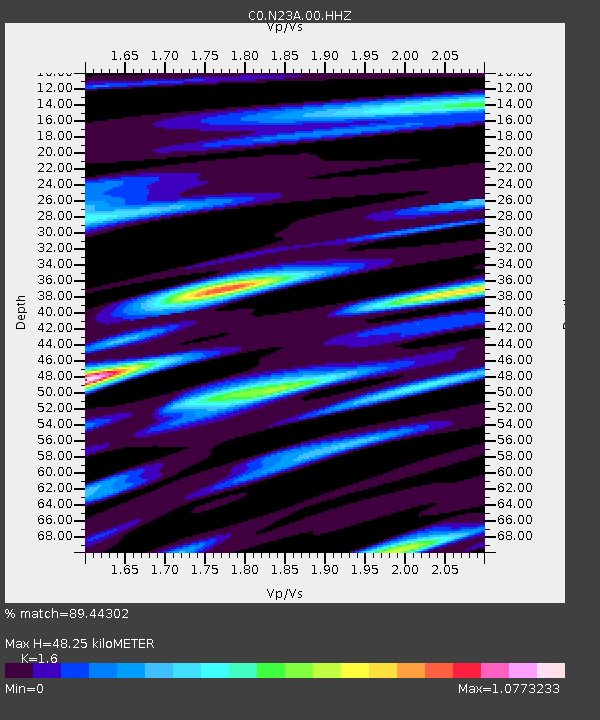
| Estimated Moho Depth: |
48.25 km |
| Estimated Crust Vp/Vs: |
1.60 |
| Assumed Crust Vp: |
6.306 km/s |
| Estimated Crust Vs: |
3.941 km/s |
| Estimated Crust Poisson's Ratio: |
0.18 |
|
| Radial Match: |
89.44302 % |
| Radial Bump: |
400 |
| Transverse Match: |
71.50307 % |
| Transverse Bump: |
400 |
| SOD ConfigId: |
30536071 |
| Insert Time: |
2023-05-08 01:11:45.135 +0000 |
| GWidth: |
2.5 |
| Max Bumps: |
400 |
| Tol: |
0.001 |
|

Signal To Noise
| Channel | StoN | STA | LTA |
| C0:N23A:00:HHZ:20230424T00:54:51.480021Z | 23.383623 | 1.7555908E-6 | 7.507779E-8 |
| C0:N23A:00:HHN:20230424T00:54:51.480021Z | 2.6253376 | 2.397767E-7 | 9.133176E-8 |
| C0:N23A:00:HHE:20230424T00:54:51.480021Z | 5.0508957 | 4.6612564E-7 | 9.2285745E-8 |
| Arrivals |
| Ps | 4.7 SECOND |
| PpPs | 19 SECOND |
| PsPs/PpSs | 24 SECOND |


