You are here: Home > Network List > TA - USArray Transportable Network (new EarthScope stations) Stations List
> Station 130A Snyder, TX, USA > Earthquake Result Viewer
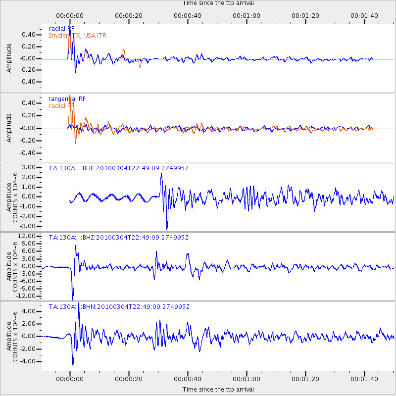
130A Snyder, TX, USA - Earthquake Result Viewer

| Earthquake location: |
Northern Chile |
| Earthquake latitude/longitude: |
-22.2/-68.3 |
| Earthquake time(UTC): |
2010/03/04 (063) 22:39:26 GMT |
| Earthquake Depth: |
114 km |
| Earthquake Magnitude: |
6.3 MB, 6.4 MW, 6.3 MW |
| Earthquake Catalog/Contributor: |
WHDF/NEIC |
|
| Network: |
TA USArray Transportable Network (new EarthScope stations) |
| Station: |
130A Snyder, TX, USA |
| Lat/Lon: |
32.60 N/100.97 W |
| Elevation: |
676 m |
|
| Distance: |
62.8 deg |
| Az: |
329.214 deg |
| Baz: |
145.818 deg |
| Ray Param: |
0.059668746 |
| Estimated Moho Depth: |
40.75 km |
| Estimated Crust Vp/Vs: |
1.82 |
| Assumed Crust Vp: |
6.426 km/s |
| Estimated Crust Vs: |
3.526 km/s |
| Estimated Crust Poisson's Ratio: |
0.28 |
|
| Radial Match: |
88.746 % |
| Radial Bump: |
400 |
| Transverse Match: |
70.99849 % |
| Transverse Bump: |
400 |
| SOD ConfigId: |
308276 |
| Insert Time: |
2010-06-22 17:00:33.098 +0000 |
| GWidth: |
2.5 |
| Max Bumps: |
400 |
| Tol: |
0.001 |
|
Signal To Noise
| Channel | StoN | STA | LTA |
| TA:130A: :BHZ:20100304T22:49:09.274995Z | 16.66246 | 4.8109255E-6 | 2.887284E-7 |
| TA:130A: :BHN:20100304T22:49:09.274995Z | 6.5495725 | 2.0385867E-6 | 3.1125492E-7 |
| TA:130A: :BHE:20100304T22:49:09.274995Z | 4.967845 | 1.2678374E-6 | 2.5520873E-7 |
| Arrivals |
| Ps | 5.4 SECOND |
| PpPs | 17 SECOND |
| PsPs/PpSs | 23 SECOND |


