You are here: Home > Network List > CI - Caltech Regional Seismic Network Stations List
> Station DAN Danby, California, USA > Earthquake Result Viewer
DAN Danby, California, USA - Earthquake Result Viewer
| Earthquake location: |
Kermadec Islands, New Zealand |
| Earthquake latitude/longitude: |
-30.0/-177.9 |
| Earthquake time(UTC): |
2023/04/24 (114) 00:41:54 GMT |
| Earthquake Depth: |
34 km |
| Earthquake Magnitude: |
7.3 mww |
| Earthquake Catalog/Contributor: |
NEIC PDE/us |
|
| Network: |
CI Caltech Regional Seismic Network |
| Station: |
DAN Danby, California, USA |
| Lat/Lon: |
34.64 N/115.38 W |
| Elevation: |
398 m |
|
| Distance: |
87.2 deg |
| Az: |
47.084 deg |
| Baz: |
230.379 deg |
| Ray Param: |
0.043429427 |
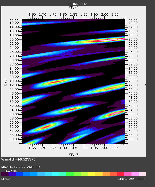
| Estimated Moho Depth: |
19.75 km |
| Estimated Crust Vp/Vs: |
2.06 |
| Assumed Crust Vp: |
6.276 km/s |
| Estimated Crust Vs: |
3.047 km/s |
| Estimated Crust Poisson's Ratio: |
0.35 |
|
| Radial Match: |
96.525375 % |
| Radial Bump: |
400 |
| Transverse Match: |
93.66217 % |
| Transverse Bump: |
400 |
| SOD ConfigId: |
30536071 |
| Insert Time: |
2023-05-08 01:14:09.999 +0000 |
| GWidth: |
2.5 |
| Max Bumps: |
400 |
| Tol: |
0.001 |
|

Signal To Noise
| Channel | StoN | STA | LTA |
| CI:DAN: :HHZ:20230424T00:54:06.668009Z | 38.95538 | 5.402046E-6 | 1.3867265E-7 |
| CI:DAN: :HHN:20230424T00:54:06.668009Z | 5.3130136 | 1.1920312E-6 | 2.2436066E-7 |
| CI:DAN: :HHE:20230424T00:54:06.668009Z | 8.004201 | 1.5441933E-6 | 1.9292285E-7 |
| Arrivals |
| Ps | 3.4 SECOND |
| PpPs | 9.5 SECOND |
| PsPs/PpSs | 13 SECOND |


