You are here: Home > Network List > CI - Caltech Regional Seismic Network Stations List
> Station IRM Iron Mountain Pumping Station, Eagle Mtn., CA, USA > Earthquake Result Viewer
IRM Iron Mountain Pumping Station, Eagle Mtn., CA, USA - Earthquake Result Viewer
| Earthquake location: |
Kermadec Islands, New Zealand |
| Earthquake latitude/longitude: |
-30.0/-177.9 |
| Earthquake time(UTC): |
2023/04/24 (114) 00:41:54 GMT |
| Earthquake Depth: |
34 km |
| Earthquake Magnitude: |
7.3 mww |
| Earthquake Catalog/Contributor: |
NEIC PDE/us |
|
| Network: |
CI Caltech Regional Seismic Network |
| Station: |
IRM Iron Mountain Pumping Station, Eagle Mtn., CA, USA |
| Lat/Lon: |
34.16 N/115.15 W |
| Elevation: |
567 m |
|
| Distance: |
87.1 deg |
| Az: |
47.577 deg |
| Baz: |
230.536 deg |
| Ray Param: |
0.043544013 |
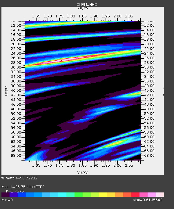
| Estimated Moho Depth: |
26.75 km |
| Estimated Crust Vp/Vs: |
1.76 |
| Assumed Crust Vp: |
6.276 km/s |
| Estimated Crust Vs: |
3.571 km/s |
| Estimated Crust Poisson's Ratio: |
0.26 |
|
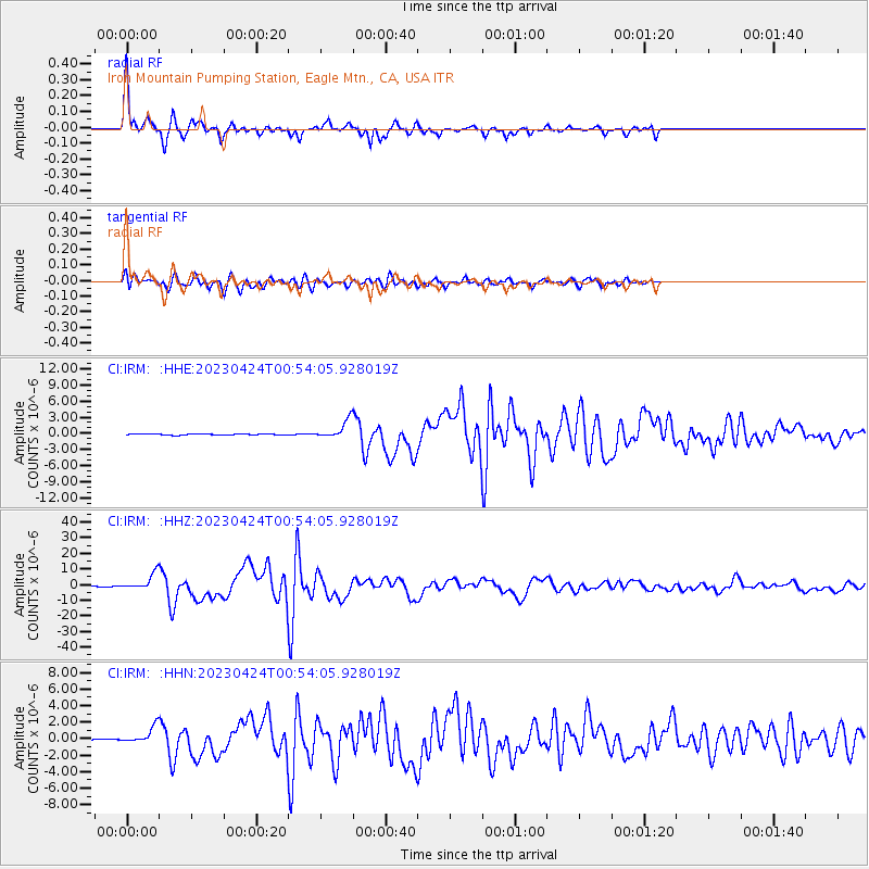
| Radial Match: |
96.72232 % |
| Radial Bump: |
268 |
| Transverse Match: |
88.71955 % |
| Transverse Bump: |
400 |
| SOD ConfigId: |
30536071 |
| Insert Time: |
2023-05-08 01:14:37.785 +0000 |
| GWidth: |
2.5 |
| Max Bumps: |
400 |
| Tol: |
0.001 |
|
Signal To Noise
| Channel | StoN | STA | LTA |
| CI:IRM: :HHZ:20230424T00:54:05.928019Z | 39.676247 | 5.034412E-6 | 1.268873E-7 |
| CI:IRM: :HHN:20230424T00:54:05.928019Z | 12.833862 | 9.670449E-7 | 7.5351046E-8 |
| CI:IRM: :HHE:20230424T00:54:05.928019Z | 18.467083 | 1.6143902E-6 | 8.741988E-8 |
| Arrivals |
| Ps | 3.3 SECOND |
| PpPs | 12 SECOND |
| PsPs/PpSs | 15 SECOND |


