You are here: Home > Network List > GM - US Geological Survey Networks Stations List
> Station NMP11 New Mexico Permian - Site# W1S1 > Earthquake Result Viewer
NMP11 New Mexico Permian - Site# W1S1 - Earthquake Result Viewer
| Earthquake location: |
Kermadec Islands, New Zealand |
| Earthquake latitude/longitude: |
-30.0/-177.9 |
| Earthquake time(UTC): |
2023/04/24 (114) 00:41:54 GMT |
| Earthquake Depth: |
34 km |
| Earthquake Magnitude: |
7.3 mww |
| Earthquake Catalog/Contributor: |
NEIC PDE/us |
|
| Network: |
GM US Geological Survey Networks |
| Station: |
NMP11 New Mexico Permian - Site# W1S1 |
| Lat/Lon: |
32.01 N/103.93 W |
| Elevation: |
883 m |
|
| Distance: |
93.4 deg |
| Az: |
54.881 deg |
| Baz: |
236.613 deg |
| Ray Param: |
0.041266624 |
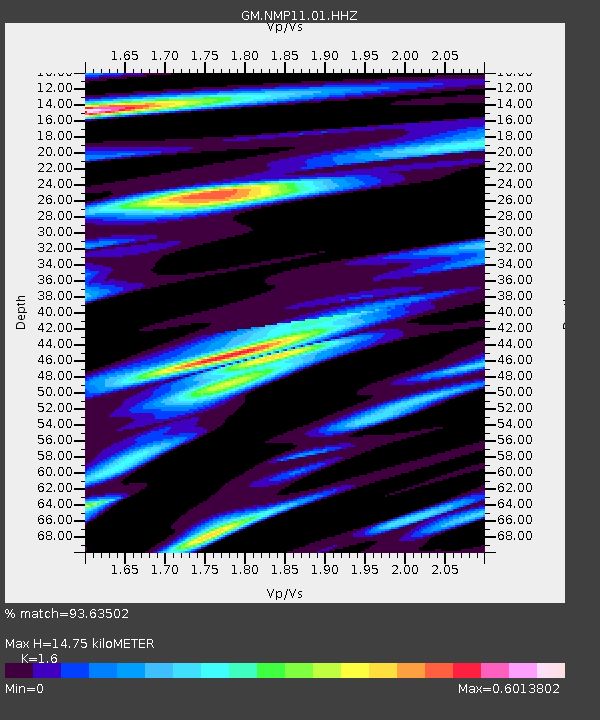
| Estimated Moho Depth: |
14.75 km |
| Estimated Crust Vp/Vs: |
1.60 |
| Assumed Crust Vp: |
6.129 km/s |
| Estimated Crust Vs: |
3.831 km/s |
| Estimated Crust Poisson's Ratio: |
0.18 |
|
| Radial Match: |
93.63502 % |
| Radial Bump: |
400 |
| Transverse Match: |
78.05207 % |
| Transverse Bump: |
400 |
| SOD ConfigId: |
30536071 |
| Insert Time: |
2023-05-08 01:18:12.001 +0000 |
| GWidth: |
2.5 |
| Max Bumps: |
400 |
| Tol: |
0.001 |
|

Signal To Noise
| Channel | StoN | STA | LTA |
| GM:NMP11:01:HHZ:20230424T00:54:35.340006Z | 14.663518 | 2.6971998E-6 | 1.8393946E-7 |
| GM:NMP11:01:HHN:20230424T00:54:35.340006Z | 2.2350698 | 3.2182527E-7 | 1.4398891E-7 |
| GM:NMP11:01:HHE:20230424T00:54:35.340006Z | 3.7955325 | 5.400656E-7 | 1.4228982E-7 |
| Arrivals |
| Ps | 1.5 SECOND |
| PpPs | 6.1 SECOND |
| PsPs/PpSs | 7.6 SECOND |


