You are here: Home > Network List > TA - USArray Transportable Network (new EarthScope stations) Stations List
> Station Q30A Quinter, KS, USA > Earthquake Result Viewer
Q30A Quinter, KS, USA - Earthquake Result Viewer
| Earthquake location: |
Northern Chile |
| Earthquake latitude/longitude: |
-22.2/-68.3 |
| Earthquake time(UTC): |
2010/03/04 (063) 22:39:26 GMT |
| Earthquake Depth: |
114 km |
| Earthquake Magnitude: |
6.3 MB, 6.4 MW, 6.3 MW |
| Earthquake Catalog/Contributor: |
WHDF/NEIC |
|
| Network: |
TA USArray Transportable Network (new EarthScope stations) |
| Station: |
Q30A Quinter, KS, USA |
| Lat/Lon: |
38.98 N/100.22 W |
| Elevation: |
797 m |
|
| Distance: |
67.8 deg |
| Az: |
333.594 deg |
| Baz: |
148.084 deg |
| Ray Param: |
0.056412227 |
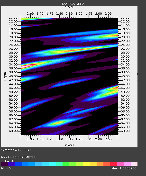
| Estimated Moho Depth: |
35.0 km |
| Estimated Crust Vp/Vs: |
1.61 |
| Assumed Crust Vp: |
6.483 km/s |
| Estimated Crust Vs: |
4.026 km/s |
| Estimated Crust Poisson's Ratio: |
0.19 |
|
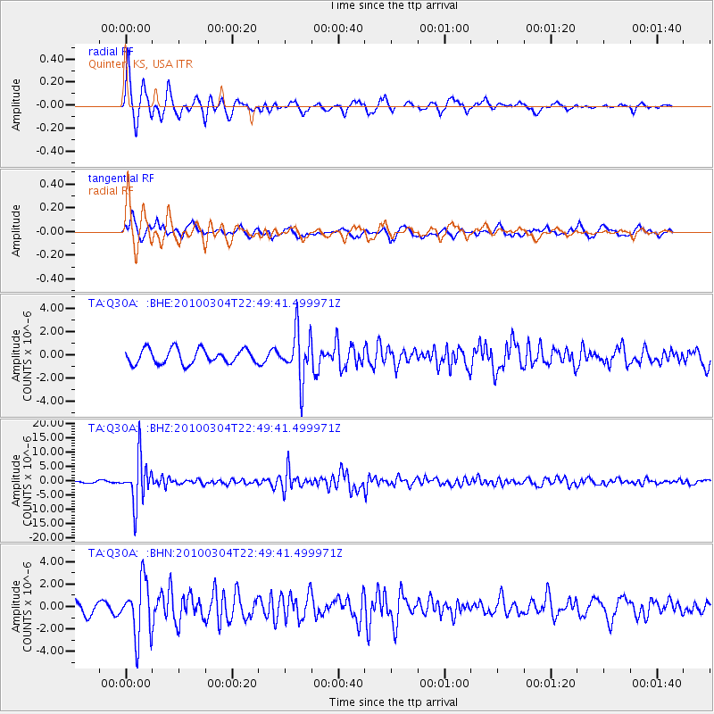
| Radial Match: |
86.03341 % |
| Radial Bump: |
297 |
| Transverse Match: |
65.78498 % |
| Transverse Bump: |
398 |
| SOD ConfigId: |
308276 |
| Insert Time: |
2010-06-22 17:03:15.749 +0000 |
| GWidth: |
2.5 |
| Max Bumps: |
400 |
| Tol: |
0.001 |
|
Signal To Noise
| Channel | StoN | STA | LTA |
| TA:Q30A: :BHZ:20100304T22:49:41.499971Z | 15.326798 | 7.911011E-6 | 5.161555E-7 |
| TA:Q30A: :BHN:20100304T22:49:41.499971Z | 4.003018 | 2.5258626E-6 | 6.309895E-7 |
| TA:Q30A: :BHE:20100304T22:49:41.499971Z | 3.3837469 | 2.107911E-6 | 6.2295175E-7 |
| Arrivals |
| Ps | 3.4 SECOND |
| PpPs | 13 SECOND |
| PsPs/PpSs | 17 SECOND |


