You are here: Home > Network List > IU - Global Seismograph Network (GSN - IRIS/USGS) Stations List
> Station COR Corvallis, Oregon, USA > Earthquake Result Viewer
COR Corvallis, Oregon, USA - Earthquake Result Viewer
| Earthquake location: |
Kermadec Islands, New Zealand |
| Earthquake latitude/longitude: |
-30.0/-177.9 |
| Earthquake time(UTC): |
2023/04/24 (114) 00:41:54 GMT |
| Earthquake Depth: |
34 km |
| Earthquake Magnitude: |
7.3 mww |
| Earthquake Catalog/Contributor: |
NEIC PDE/us |
|
| Network: |
IU Global Seismograph Network (GSN - IRIS/USGS) |
| Station: |
COR Corvallis, Oregon, USA |
| Lat/Lon: |
44.59 N/123.30 W |
| Elevation: |
121 m |
|
| Distance: |
89.4 deg |
| Az: |
35.623 deg |
| Baz: |
224.984 deg |
| Ray Param: |
0.041850086 |
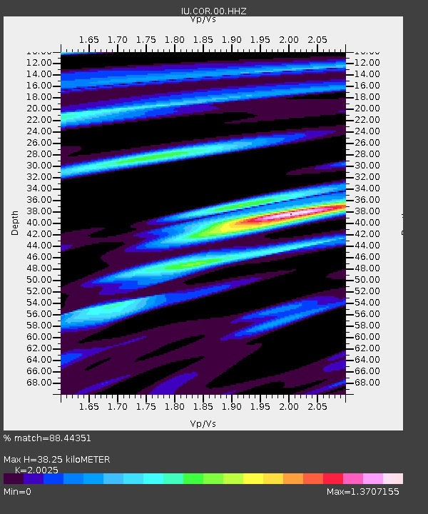
| Estimated Moho Depth: |
38.25 km |
| Estimated Crust Vp/Vs: |
2.00 |
| Assumed Crust Vp: |
6.566 km/s |
| Estimated Crust Vs: |
3.279 km/s |
| Estimated Crust Poisson's Ratio: |
0.33 |
|
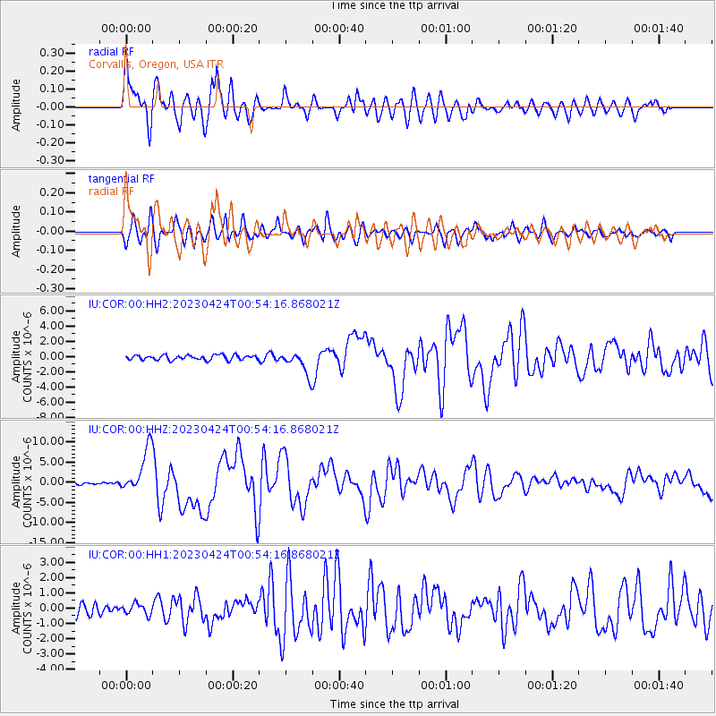
| Radial Match: |
88.44351 % |
| Radial Bump: |
400 |
| Transverse Match: |
80.42393 % |
| Transverse Bump: |
400 |
| SOD ConfigId: |
30536071 |
| Insert Time: |
2023-05-08 01:19:52.067 +0000 |
| GWidth: |
2.5 |
| Max Bumps: |
400 |
| Tol: |
0.001 |
|
Signal To Noise
| Channel | StoN | STA | LTA |
| IU:COR:00:HHZ:20230424T00:54:16.868021Z | 13.197266 | 5.6870576E-6 | 4.3092697E-7 |
| IU:COR:00:HH1:20230424T00:54:16.868021Z | 0.8903814 | 3.5135432E-7 | 3.9461102E-7 |
| IU:COR:00:HH2:20230424T00:54:16.868021Z | 5.093076 | 1.597001E-6 | 3.1356313E-7 |
| Arrivals |
| Ps | 6.0 SECOND |
| PpPs | 17 SECOND |
| PsPs/PpSs | 23 SECOND |


