You are here: Home > Network List > IW - Intermountain West Stations List
> Station MOOW Moose Ponds, Wyoming, USA > Earthquake Result Viewer
MOOW Moose Ponds, Wyoming, USA - Earthquake Result Viewer
| Earthquake location: |
Kermadec Islands, New Zealand |
| Earthquake latitude/longitude: |
-30.0/-177.9 |
| Earthquake time(UTC): |
2023/04/24 (114) 00:41:54 GMT |
| Earthquake Depth: |
34 km |
| Earthquake Magnitude: |
7.3 mww |
| Earthquake Catalog/Contributor: |
NEIC PDE/us |
|
| Network: |
IW Intermountain West |
| Station: |
MOOW Moose Ponds, Wyoming, USA |
| Lat/Lon: |
43.75 N/110.74 W |
| Elevation: |
2128 m |
|
| Distance: |
95.7 deg |
| Az: |
42.155 deg |
| Baz: |
233.433 deg |
| Ray Param: |
0.040712334 |
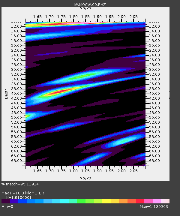
| Estimated Moho Depth: |
10.0 km |
| Estimated Crust Vp/Vs: |
1.91 |
| Assumed Crust Vp: |
6.207 km/s |
| Estimated Crust Vs: |
3.25 km/s |
| Estimated Crust Poisson's Ratio: |
0.31 |
|
| Radial Match: |
95.11924 % |
| Radial Bump: |
400 |
| Transverse Match: |
88.96782 % |
| Transverse Bump: |
400 |
| SOD ConfigId: |
30536071 |
| Insert Time: |
2023-05-08 01:20:19.720 +0000 |
| GWidth: |
2.5 |
| Max Bumps: |
400 |
| Tol: |
0.001 |
|
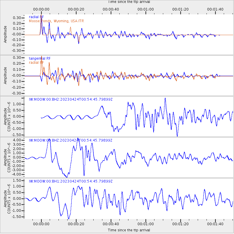
Signal To Noise
| Channel | StoN | STA | LTA |
| IW:MOOW:00:BHZ:20230424T00:54:45.79899Z | 23.590343 | 2.1738808E-6 | 9.21513E-8 |
| IW:MOOW:00:BH1:20230424T00:54:45.79899Z | 6.6385245 | 4.4042233E-7 | 6.634341E-8 |
| IW:MOOW:00:BH2:20230424T00:54:45.79899Z | 3.893521 | 4.1265463E-7 | 1.0598495E-7 |
| Arrivals |
| Ps | 1.5 SECOND |
| PpPs | 4.6 SECOND |
| PsPs/PpSs | 6.1 SECOND |


