You are here: Home > Network List > TA - USArray Transportable Network (new EarthScope stations) Stations List
> Station N29A Votaw Ranch, Wellfleet, NE, USA > Earthquake Result Viewer
N29A Votaw Ranch, Wellfleet, NE, USA - Earthquake Result Viewer
| Earthquake location: |
Northern Chile |
| Earthquake latitude/longitude: |
-22.2/-68.3 |
| Earthquake time(UTC): |
2010/03/04 (063) 22:39:26 GMT |
| Earthquake Depth: |
114 km |
| Earthquake Magnitude: |
6.3 MB, 6.4 MW, 6.3 MW |
| Earthquake Catalog/Contributor: |
WHDF/NEIC |
|
| Network: |
TA USArray Transportable Network (new EarthScope stations) |
| Station: |
N29A Votaw Ranch, Wellfleet, NE, USA |
| Lat/Lon: |
40.82 N/100.63 W |
| Elevation: |
897 m |
|
| Distance: |
69.5 deg |
| Az: |
334.353 deg |
| Baz: |
148.101 deg |
| Ray Param: |
0.055281695 |
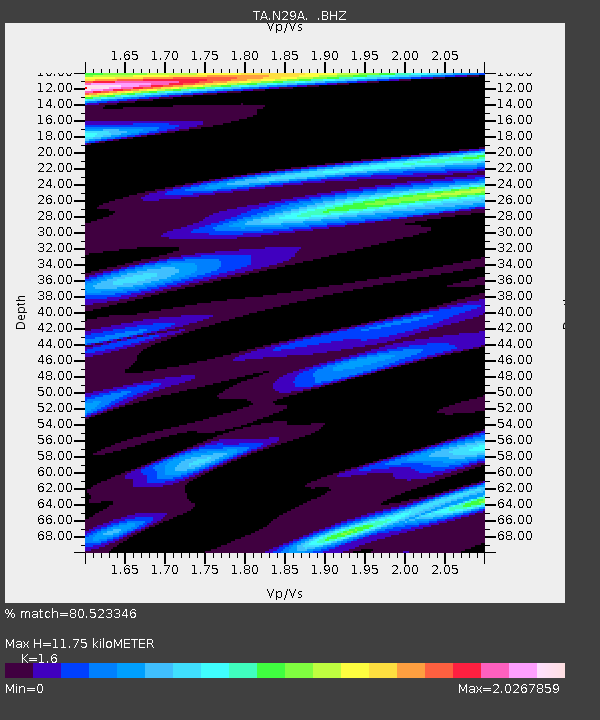
| Estimated Moho Depth: |
11.75 km |
| Estimated Crust Vp/Vs: |
1.60 |
| Assumed Crust Vp: |
6.483 km/s |
| Estimated Crust Vs: |
4.052 km/s |
| Estimated Crust Poisson's Ratio: |
0.18 |
|
| Radial Match: |
80.523346 % |
| Radial Bump: |
400 |
| Transverse Match: |
70.15937 % |
| Transverse Bump: |
400 |
| SOD ConfigId: |
308276 |
| Insert Time: |
2010-06-22 17:04:03.720 +0000 |
| GWidth: |
2.5 |
| Max Bumps: |
400 |
| Tol: |
0.001 |
|
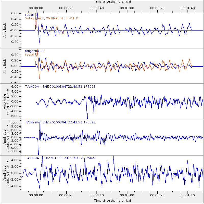
Signal To Noise
| Channel | StoN | STA | LTA |
| TA:N29A: :BHZ:20100304T22:49:52.17502Z | 12.73116 | 5.48222E-6 | 4.306143E-7 |
| TA:N29A: :BHN:20100304T22:49:52.17502Z | 3.3905587 | 2.4938693E-6 | 7.3553343E-7 |
| TA:N29A: :BHE:20100304T22:49:52.17502Z | 2.9895668 | 2.390738E-6 | 7.996938E-7 |
| Arrivals |
| Ps | 1.1 SECOND |
| PpPs | 4.5 SECOND |
| PsPs/PpSs | 5.7 SECOND |


