You are here: Home > Network List > NN - Western Great Basin/Eastern Sierra Nevada Stations List
> Station PRN Pahroc Range, Nevada. (GPS 12/04/2000) w84 > Earthquake Result Viewer
PRN Pahroc Range, Nevada. (GPS 12/04/2000) w84 - Earthquake Result Viewer
| Earthquake location: |
Kermadec Islands, New Zealand |
| Earthquake latitude/longitude: |
-30.0/-177.9 |
| Earthquake time(UTC): |
2023/04/24 (114) 00:41:54 GMT |
| Earthquake Depth: |
34 km |
| Earthquake Magnitude: |
7.3 mww |
| Earthquake Catalog/Contributor: |
NEIC PDE/us |
|
| Network: |
NN Western Great Basin/Eastern Sierra Nevada |
| Station: |
PRN Pahroc Range, Nevada. (GPS 12/04/2000) w84 |
| Lat/Lon: |
37.41 N/115.05 W |
| Elevation: |
1464 m |
|
| Distance: |
89.2 deg |
| Az: |
45.122 deg |
| Baz: |
230.511 deg |
| Ray Param: |
0.04198987 |
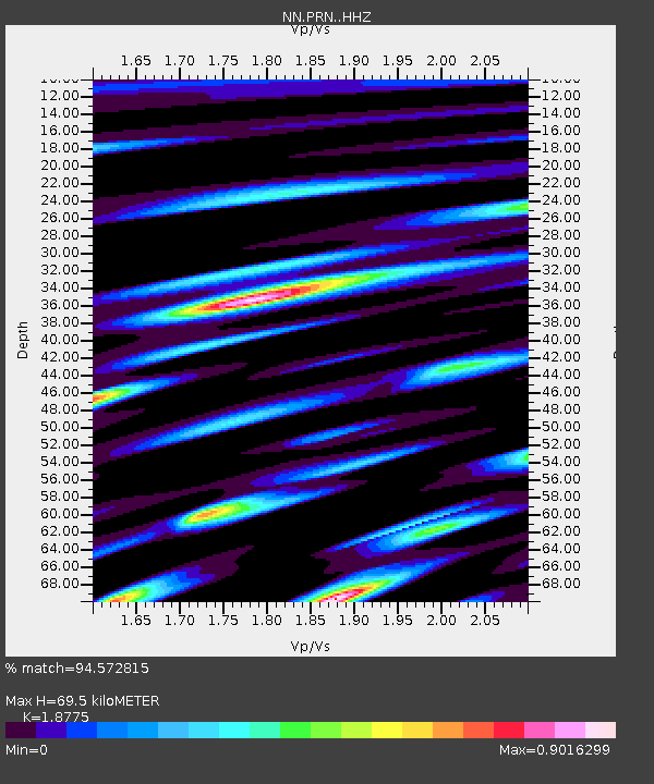
| Estimated Moho Depth: |
69.5 km |
| Estimated Crust Vp/Vs: |
1.88 |
| Assumed Crust Vp: |
6.276 km/s |
| Estimated Crust Vs: |
3.343 km/s |
| Estimated Crust Poisson's Ratio: |
0.30 |
|
| Radial Match: |
94.572815 % |
| Radial Bump: |
400 |
| Transverse Match: |
85.045296 % |
| Transverse Bump: |
400 |
| SOD ConfigId: |
30536071 |
| Insert Time: |
2023-05-08 01:22:03.266 +0000 |
| GWidth: |
2.5 |
| Max Bumps: |
400 |
| Tol: |
0.001 |
|

Signal To Noise
| Channel | StoN | STA | LTA |
| NN:PRN: :HHZ:20230424T00:54:15.999002Z | 25.339546 | 3.3585457E-6 | 1.3254166E-7 |
| NN:PRN: :HHN:20230424T00:54:15.999002Z | 5.2246857 | 7.2983045E-7 | 1.3968886E-7 |
| NN:PRN: :HHE:20230424T00:54:15.999002Z | 10.505501 | 8.5513415E-7 | 8.13987E-8 |
| Arrivals |
| Ps | 9.9 SECOND |
| PpPs | 31 SECOND |
| PsPs/PpSs | 41 SECOND |


