You are here: Home > Network List > TA - USArray Transportable Network (new EarthScope stations) Stations List
> Station H27A Howes, SD, USA > Earthquake Result Viewer
H27A Howes, SD, USA - Earthquake Result Viewer

| Earthquake location: |
Northern Chile |
| Earthquake latitude/longitude: |
-22.2/-68.3 |
| Earthquake time(UTC): |
2010/03/04 (063) 22:39:26 GMT |
| Earthquake Depth: |
114 km |
| Earthquake Magnitude: |
6.3 MB, 6.4 MW, 6.3 MW |
| Earthquake Catalog/Contributor: |
WHDF/NEIC |
|
| Network: |
TA USArray Transportable Network (new EarthScope stations) |
| Station: |
H27A Howes, SD, USA |
| Lat/Lon: |
44.63 N/102.08 W |
| Elevation: |
748 m |
|
| Distance: |
73.3 deg |
| Az: |
335.541 deg |
| Baz: |
147.498 deg |
| Ray Param: |
0.05279028 |
| Estimated Moho Depth: |
16.5 km |
| Estimated Crust Vp/Vs: |
1.60 |
| Assumed Crust Vp: |
6.242 km/s |
| Estimated Crust Vs: |
3.901 km/s |
| Estimated Crust Poisson's Ratio: |
0.18 |
|
| Radial Match: |
84.86883 % |
| Radial Bump: |
335 |
| Transverse Match: |
70.730515 % |
| Transverse Bump: |
375 |
| SOD ConfigId: |
308276 |
| Insert Time: |
2010-06-22 17:05:15.424 +0000 |
| GWidth: |
2.5 |
| Max Bumps: |
400 |
| Tol: |
0.001 |
|
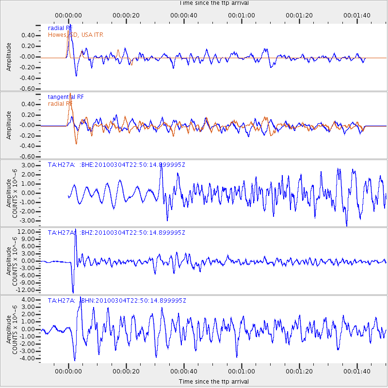
Signal To Noise
| Channel | StoN | STA | LTA |
| TA:H27A: :BHZ:20100304T22:50:14.899995Z | 16.27052 | 5.555065E-6 | 3.4141902E-7 |
| TA:H27A: :BHN:20100304T22:50:14.899995Z | 4.473103 | 2.284868E-6 | 5.1080156E-7 |
| TA:H27A: :BHE:20100304T22:50:14.899995Z | 2.075282 | 1.4382003E-6 | 6.930144E-7 |
| Arrivals |
| Ps | 1.6 SECOND |
| PpPs | 6.6 SECOND |
| PsPs/PpSs | 8.3 SECOND |


