You are here: Home > Network List > RV - Regional Alberta Seismic Observatory for Earthquake Studies Network Stations List
> Station PKSKA Pekisko, AB > Earthquake Result Viewer
PKSKA Pekisko, AB - Earthquake Result Viewer
| Earthquake location: |
Kermadec Islands, New Zealand |
| Earthquake latitude/longitude: |
-30.0/-177.9 |
| Earthquake time(UTC): |
2023/04/24 (114) 00:41:54 GMT |
| Earthquake Depth: |
34 km |
| Earthquake Magnitude: |
7.3 mww |
| Earthquake Catalog/Contributor: |
NEIC PDE/us |
|
| Network: |
RV Regional Alberta Seismic Observatory for Earthquake Studies Network |
| Station: |
PKSKA Pekisko, AB |
| Lat/Lon: |
50.43 N/114.12 W |
| Elevation: |
1231 m |
|
| Distance: |
97.9 deg |
| Az: |
35.394 deg |
| Baz: |
231.763 deg |
| Ray Param: |
0.04005237 |
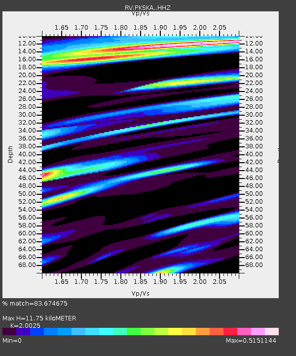
| Estimated Moho Depth: |
11.75 km |
| Estimated Crust Vp/Vs: |
2.00 |
| Assumed Crust Vp: |
6.178 km/s |
| Estimated Crust Vs: |
3.085 km/s |
| Estimated Crust Poisson's Ratio: |
0.33 |
|
| Radial Match: |
83.674675 % |
| Radial Bump: |
400 |
| Transverse Match: |
71.45501 % |
| Transverse Bump: |
400 |
| SOD ConfigId: |
30536071 |
| Insert Time: |
2023-05-08 01:24:21.424 +0000 |
| GWidth: |
2.5 |
| Max Bumps: |
400 |
| Tol: |
0.001 |
|

Signal To Noise
| Channel | StoN | STA | LTA |
| RV:PKSKA: :HHZ:20230424T00:54:55.769999Z | 11.164264 | 1.5592458E-6 | 1.3966401E-7 |
| RV:PKSKA: :HHN:20230424T00:54:55.769999Z | 0.94856346 | 1.7084238E-7 | 1.8010643E-7 |
| RV:PKSKA: :HHE:20230424T00:54:55.769999Z | 1.2688124 | 3.2745962E-7 | 2.5808356E-7 |
| Arrivals |
| Ps | 1.9 SECOND |
| PpPs | 5.6 SECOND |
| PsPs/PpSs | 7.6 SECOND |


