You are here: Home > Network List > WY - Yellowstone Wyoming Seismic Network Stations List
> Station YHH Holmes Hill, YNP, WY, USA > Earthquake Result Viewer
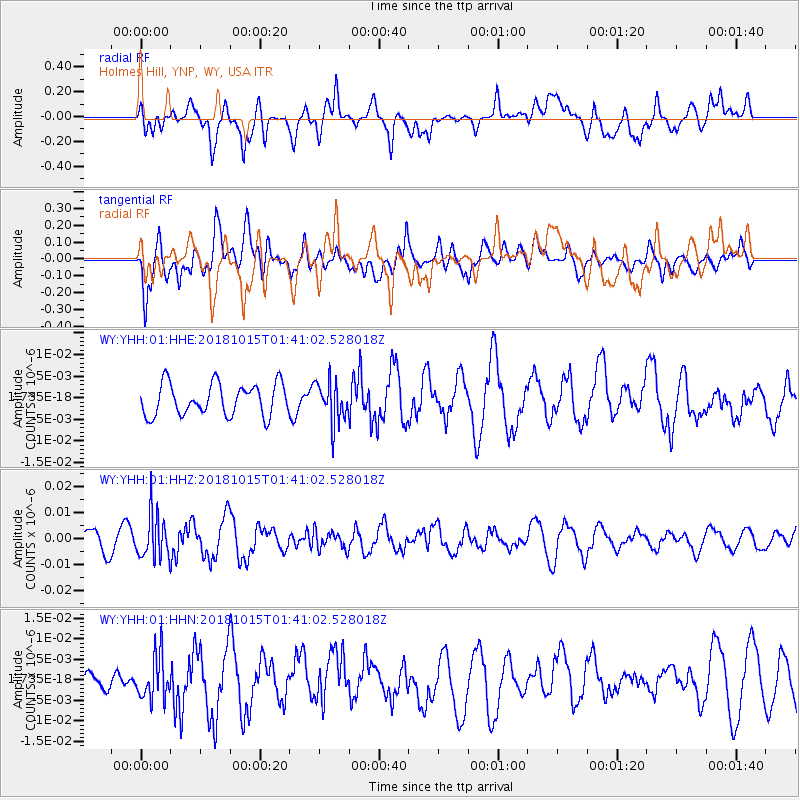
YHH Holmes Hill, YNP, WY, USA - Earthquake Result Viewer
*The percent match for this event was below the threshold and hence no stack was calculated.
| Earthquake location: |
Near East Coast Of Kamchatka |
| Earthquake latitude/longitude: |
54.1/159.5 |
| Earthquake time(UTC): |
2018/10/15 (288) 01:32:12 GMT |
| Earthquake Depth: |
124 km |
| Earthquake Magnitude: |
5.6 mb |
| Earthquake Catalog/Contributor: |
NEIC PDE/us |
|
| Network: |
WY Yellowstone Wyoming Seismic Network |
| Station: |
YHH Holmes Hill, YNP, WY, USA |
| Lat/Lon: |
44.79 N/110.85 W |
| Elevation: |
2717 m |
|
| Distance: |
55.3 deg |
| Az: |
60.023 deg |
| Baz: |
314.188 deg |
| Ray Param: |
$rayparam |
*The percent match for this event was below the threshold and hence was not used in the summary stack. |
|
| Radial Match: |
72.12474 % |
| Radial Bump: |
400 |
| Transverse Match: |
60.364285 % |
| Transverse Bump: |
400 |
| SOD ConfigId: |
3045211 |
| Insert Time: |
2018-10-29 01:44:14.749 +0000 |
| GWidth: |
2.5 |
| Max Bumps: |
400 |
| Tol: |
0.001 |
|
Signal To Noise
| Channel | StoN | STA | LTA |
| WY:YHH:01:HHZ:20181015T01:41:02.528018Z | 2.3951912 | 8.502257E-9 | 3.5497196E-9 |
| WY:YHH:01:HHN:20181015T01:41:02.528018Z | 1.5701538 | 5.3857687E-9 | 3.4300895E-9 |
| WY:YHH:01:HHE:20181015T01:41:02.528018Z | 1.2684215 | 4.6558126E-9 | 3.670556E-9 |
| Arrivals |
| Ps | |
| PpPs | |
| PsPs/PpSs | |


