You are here: Home > Network List > TA - USArray Transportable Network (new EarthScope stations) Stations List
> Station D26A Manning, ND, USA > Earthquake Result Viewer
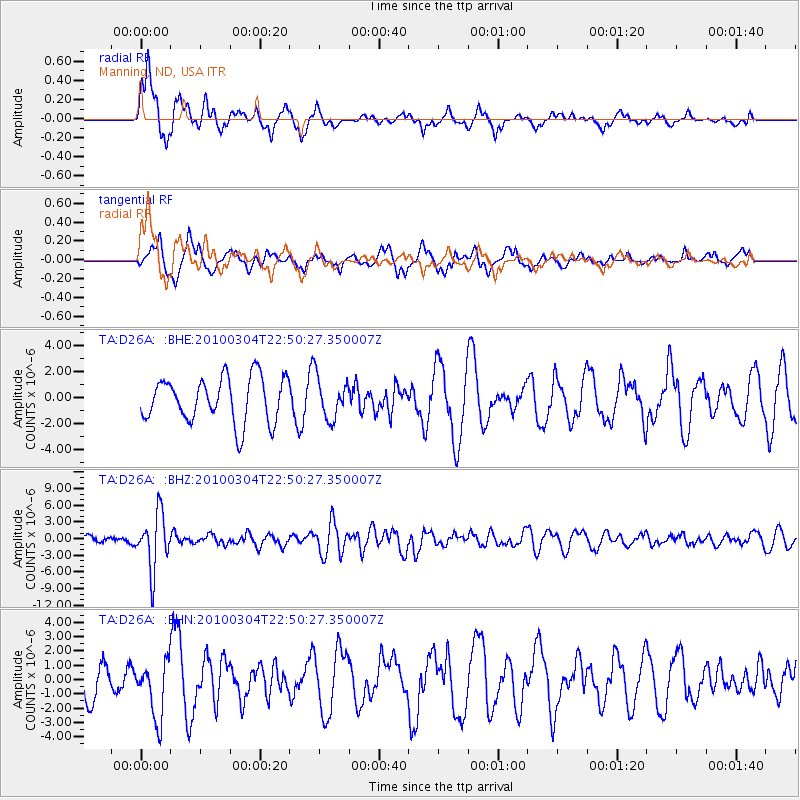
D26A Manning, ND, USA - Earthquake Result Viewer
*The percent match for this event was below the threshold and hence no stack was calculated.
| Earthquake location: |
Northern Chile |
| Earthquake latitude/longitude: |
-22.2/-68.3 |
| Earthquake time(UTC): |
2010/03/04 (063) 22:39:26 GMT |
| Earthquake Depth: |
114 km |
| Earthquake Magnitude: |
6.3 MB, 6.4 MW, 6.3 MW |
| Earthquake Catalog/Contributor: |
WHDF/NEIC |
|
| Network: |
TA USArray Transportable Network (new EarthScope stations) |
| Station: |
D26A Manning, ND, USA |
| Lat/Lon: |
47.03 N/102.44 W |
| Elevation: |
693 m |
|
| Distance: |
75.5 deg |
| Az: |
336.658 deg |
| Baz: |
147.542 deg |
| Ray Param: |
$rayparam |
*The percent match for this event was below the threshold and hence was not used in the summary stack. |
|
| Radial Match: |
65.80177 % |
| Radial Bump: |
383 |
| Transverse Match: |
41.539146 % |
| Transverse Bump: |
317 |
| SOD ConfigId: |
308276 |
| Insert Time: |
2010-06-22 17:06:42.018 +0000 |
| GWidth: |
2.5 |
| Max Bumps: |
400 |
| Tol: |
0.001 |
|
Signal To Noise
| Channel | StoN | STA | LTA |
| TA:D26A: :BHZ:20100304T22:50:27.350007Z | 7.184251 | 4.976084E-6 | 6.9263785E-7 |
| TA:D26A: :BHN:20100304T22:50:27.350007Z | 1.3816041 | 2.026301E-6 | 1.4666292E-6 |
| TA:D26A: :BHE:20100304T22:50:27.350007Z | 0.9198699 | 1.5843752E-6 | 1.7223906E-6 |
| Arrivals |
| Ps | |
| PpPs | |
| PsPs/PpSs | |


