You are here: Home > Network List > TA - USArray Transportable Network (new EarthScope stations) Stations List
> Station D30A Buchanan, ND, USA > Earthquake Result Viewer
D30A Buchanan, ND, USA - Earthquake Result Viewer
| Earthquake location: |
Northern Chile |
| Earthquake latitude/longitude: |
-22.2/-68.3 |
| Earthquake time(UTC): |
2010/03/04 (063) 22:39:26 GMT |
| Earthquake Depth: |
114 km |
| Earthquake Magnitude: |
6.3 MB, 6.4 MW, 6.3 MW |
| Earthquake Catalog/Contributor: |
WHDF/NEIC |
|
| Network: |
TA USArray Transportable Network (new EarthScope stations) |
| Station: |
D30A Buchanan, ND, USA |
| Lat/Lon: |
47.11 N/98.76 W |
| Elevation: |
465 m |
|
| Distance: |
74.3 deg |
| Az: |
338.936 deg |
| Baz: |
150.821 deg |
| Ray Param: |
0.052164983 |
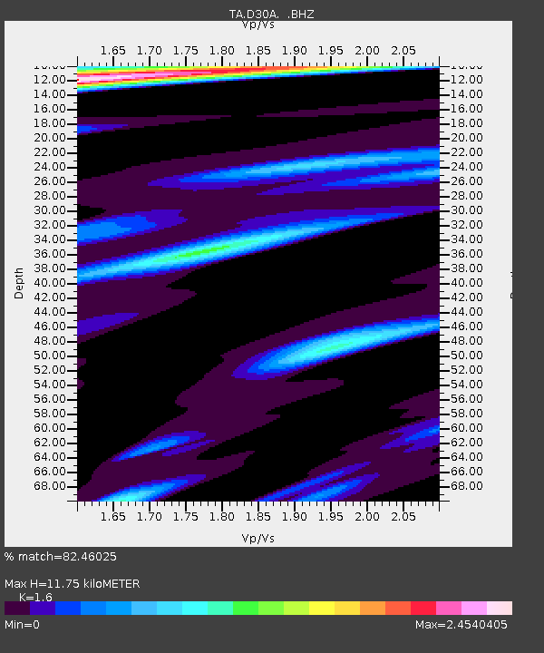
| Estimated Moho Depth: |
11.75 km |
| Estimated Crust Vp/Vs: |
1.60 |
| Assumed Crust Vp: |
6.53 km/s |
| Estimated Crust Vs: |
4.082 km/s |
| Estimated Crust Poisson's Ratio: |
0.18 |
|
| Radial Match: |
82.46025 % |
| Radial Bump: |
356 |
| Transverse Match: |
62.950165 % |
| Transverse Bump: |
367 |
| SOD ConfigId: |
308276 |
| Insert Time: |
2010-06-22 17:07:53.821 +0000 |
| GWidth: |
2.5 |
| Max Bumps: |
400 |
| Tol: |
0.001 |
|
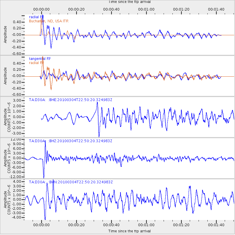
Signal To Noise
| Channel | StoN | STA | LTA |
| TA:D30A: :BHZ:20100304T22:50:20.324983Z | 12.125182 | 4.836973E-6 | 3.989196E-7 |
| TA:D30A: :BHN:20100304T22:50:20.324983Z | 2.4622679 | 2.004577E-6 | 8.141182E-7 |
| TA:D30A: :BHE:20100304T22:50:20.324983Z | 3.5929976 | 1.6094127E-6 | 4.4793038E-7 |
| Arrivals |
| Ps | 1.1 SECOND |
| PpPs | 4.5 SECOND |
| PsPs/PpSs | 5.6 SECOND |


