You are here: Home > Network List > UO - University of Oregon Regional Network Stations List
> Station VITI Monroe, OR, USA > Earthquake Result Viewer
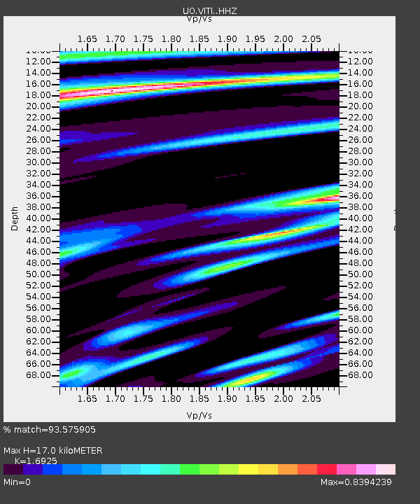
VITI Monroe, OR, USA - Earthquake Result Viewer
| Earthquake location: |
Kermadec Islands, New Zealand |
| Earthquake latitude/longitude: |
-30.0/-177.9 |
| Earthquake time(UTC): |
2023/04/24 (114) 00:41:54 GMT |
| Earthquake Depth: |
34 km |
| Earthquake Magnitude: |
7.3 mww |
| Earthquake Catalog/Contributor: |
NEIC PDE/us |
|
| Network: |
UO University of Oregon Regional Network |
| Station: |
VITI Monroe, OR, USA |
| Lat/Lon: |
44.28 N/123.32 W |
| Elevation: |
258 m |
|
| Distance: |
89.2 deg |
| Az: |
35.83 deg |
| Baz: |
224.977 deg |
| Ray Param: |
0.042015117 |
| Estimated Moho Depth: |
17.0 km |
| Estimated Crust Vp/Vs: |
1.69 |
| Assumed Crust Vp: |
6.566 km/s |
| Estimated Crust Vs: |
3.88 km/s |
| Estimated Crust Poisson's Ratio: |
0.23 |
|
| Radial Match: |
93.575905 % |
| Radial Bump: |
400 |
| Transverse Match: |
87.34343 % |
| Transverse Bump: |
400 |
| SOD ConfigId: |
30536071 |
| Insert Time: |
2023-05-08 01:29:00.817 +0000 |
| GWidth: |
2.5 |
| Max Bumps: |
400 |
| Tol: |
0.001 |
|

Signal To Noise
| Channel | StoN | STA | LTA |
| UO:VITI: :HHZ:20230424T00:54:15.840006Z | 18.992498 | 5.124036E-6 | 2.6979265E-7 |
| UO:VITI: :HHN:20230424T00:54:15.840006Z | 5.2565756 | 1.1322844E-6 | 2.1540343E-7 |
| UO:VITI: :HHE:20230424T00:54:15.840006Z | 5.9045753 | 1.2999518E-6 | 2.2016009E-7 |
| Arrivals |
| Ps | 1.8 SECOND |
| PpPs | 6.8 SECOND |
| PsPs/PpSs | 8.6 SECOND |


