You are here: Home > Network List > US - United States National Seismic Network Stations List
> Station AMTX Amarillo, Texas, USA > Earthquake Result Viewer
AMTX Amarillo, Texas, USA - Earthquake Result Viewer

| Earthquake location: |
Kermadec Islands, New Zealand |
| Earthquake latitude/longitude: |
-30.0/-177.9 |
| Earthquake time(UTC): |
2023/04/24 (114) 00:41:54 GMT |
| Earthquake Depth: |
34 km |
| Earthquake Magnitude: |
7.3 mww |
| Earthquake Catalog/Contributor: |
NEIC PDE/us |
|
| Network: |
US United States National Seismic Network |
| Station: |
AMTX Amarillo, Texas, USA |
| Lat/Lon: |
34.53 N/101.41 W |
| Elevation: |
1010 m |
|
| Distance: |
96.5 deg |
| Az: |
53.899 deg |
| Baz: |
238.076 deg |
| Ray Param: |
0.040475126 |
| Estimated Moho Depth: |
45.5 km |
| Estimated Crust Vp/Vs: |
1.87 |
| Assumed Crust Vp: |
6.426 km/s |
| Estimated Crust Vs: |
3.446 km/s |
| Estimated Crust Poisson's Ratio: |
0.30 |
|
| Radial Match: |
95.14196 % |
| Radial Bump: |
400 |
| Transverse Match: |
84.05134 % |
| Transverse Bump: |
400 |
| SOD ConfigId: |
30536071 |
| Insert Time: |
2023-05-08 01:29:20.517 +0000 |
| GWidth: |
2.5 |
| Max Bumps: |
400 |
| Tol: |
0.001 |
|
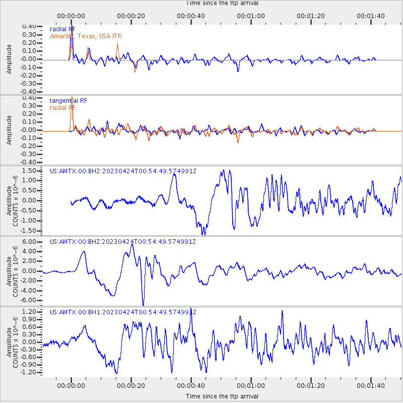
Signal To Noise
| Channel | StoN | STA | LTA |
| US:AMTX:00:BHZ:20230424T00:54:49.574991Z | 17.800322 | 2.2599086E-6 | 1.2695887E-7 |
| US:AMTX:00:BH1:20230424T00:54:49.574991Z | 3.5301645 | 3.4202833E-7 | 9.688737E-8 |
| US:AMTX:00:BH2:20230424T00:54:49.574991Z | 4.3432546 | 6.874525E-7 | 1.582805E-7 |
| Arrivals |
| Ps | 6.2 SECOND |
| PpPs | 20 SECOND |
| PsPs/PpSs | 26 SECOND |


