You are here: Home > Network List > US - United States National Seismic Network Stations List
> Station DUG Dugway, Tooele County, Utah, USA > Earthquake Result Viewer
DUG Dugway, Tooele County, Utah, USA - Earthquake Result Viewer
| Earthquake location: |
Kermadec Islands, New Zealand |
| Earthquake latitude/longitude: |
-30.0/-177.9 |
| Earthquake time(UTC): |
2023/04/24 (114) 00:41:54 GMT |
| Earthquake Depth: |
34 km |
| Earthquake Magnitude: |
7.3 mww |
| Earthquake Catalog/Contributor: |
NEIC PDE/us |
|
| Network: |
US United States National Seismic Network |
| Station: |
DUG Dugway, Tooele County, Utah, USA |
| Lat/Lon: |
40.19 N/112.81 W |
| Elevation: |
1477 m |
|
| Distance: |
92.3 deg |
| Az: |
44.047 deg |
| Baz: |
231.922 deg |
| Ray Param: |
0.041471526 |
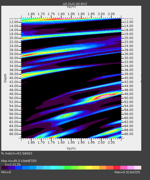
| Estimated Moho Depth: |
49.0 km |
| Estimated Crust Vp/Vs: |
2.01 |
| Assumed Crust Vp: |
6.276 km/s |
| Estimated Crust Vs: |
3.118 km/s |
| Estimated Crust Poisson's Ratio: |
0.34 |
|
| Radial Match: |
93.56583 % |
| Radial Bump: |
400 |
| Transverse Match: |
78.18391 % |
| Transverse Bump: |
400 |
| SOD ConfigId: |
30536071 |
| Insert Time: |
2023-05-08 01:29:27.014 +0000 |
| GWidth: |
2.5 |
| Max Bumps: |
400 |
| Tol: |
0.001 |
|

Signal To Noise
| Channel | StoN | STA | LTA |
| US:DUG:00:BHZ:20230424T00:54:30.374002Z | 40.61072 | 2.82126E-6 | 6.947082E-8 |
| US:DUG:00:BH1:20230424T00:54:30.374002Z | 5.099264 | 4.624741E-7 | 9.069428E-8 |
| US:DUG:00:BH2:20230424T00:54:30.374002Z | 8.027889 | 6.309056E-7 | 7.858923E-8 |
| Arrivals |
| Ps | 8.0 SECOND |
| PpPs | 23 SECOND |
| PsPs/PpSs | 31 SECOND |


