You are here: Home > Network List > GS - US Geological Survey Networks Stations List
> Station KAN09 Caldwell North Station > Earthquake Result Viewer
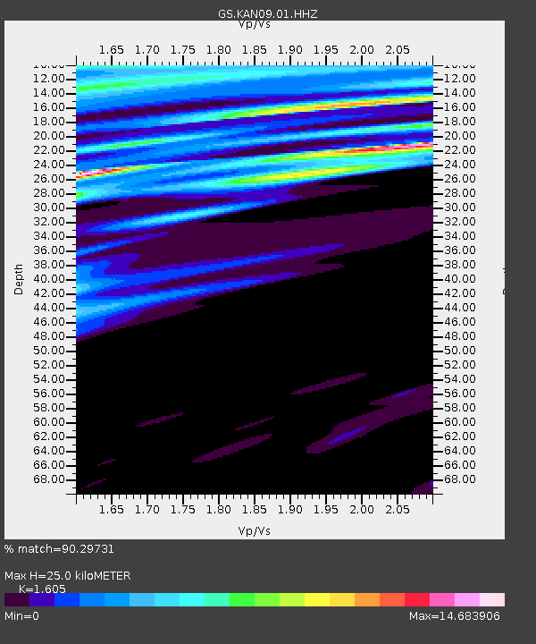
KAN09 Caldwell North Station - Earthquake Result Viewer
| Earthquake location: |
Salta Province, Argentina |
| Earthquake latitude/longitude: |
-24.0/-67.0 |
| Earthquake time(UTC): |
2018/10/15 (288) 12:58:55 GMT |
| Earthquake Depth: |
163 km |
| Earthquake Magnitude: |
5.5 Mww |
| Earthquake Catalog/Contributor: |
NEIC PDE/us |
|
| Network: |
GS US Geological Survey Networks |
| Station: |
KAN09 Caldwell North Station |
| Lat/Lon: |
37.14 N/97.62 W |
| Elevation: |
371 m |
|
| Distance: |
67.3 deg |
| Az: |
333.824 deg |
| Baz: |
149.686 deg |
| Ray Param: |
0.056574665 |
| Estimated Moho Depth: |
25.0 km |
| Estimated Crust Vp/Vs: |
1.61 |
| Assumed Crust Vp: |
6.483 km/s |
| Estimated Crust Vs: |
4.039 km/s |
| Estimated Crust Poisson's Ratio: |
0.18 |
|
| Radial Match: |
90.29731 % |
| Radial Bump: |
353 |
| Transverse Match: |
92.29029 % |
| Transverse Bump: |
330 |
| SOD ConfigId: |
3045211 |
| Insert Time: |
2018-10-29 13:06:56.985 +0000 |
| GWidth: |
2.5 |
| Max Bumps: |
400 |
| Tol: |
0.001 |
|

Signal To Noise
| Channel | StoN | STA | LTA |
| GS:KAN09:01:HHZ:20181015T13:09:01.864021Z | 0.7662474 | 2.0147324E-7 | 2.6293498E-7 |
| GS:KAN09:01:HHN:20181015T13:09:01.864021Z | 1.3754845 | 1.8814886E-6 | 1.3678733E-6 |
| GS:KAN09:01:HHE:20181015T13:09:01.864021Z | 0.3075157 | 2.2591203E-6 | 7.346357E-6 |
| Arrivals |
| Ps | 2.4 SECOND |
| PpPs | 9.6 SECOND |
| PsPs/PpSs | 12 SECOND |


