You are here: Home > Network List > US - United States National Seismic Network Stations List
> Station WUAZ Wupatki, Arizona, USA > Earthquake Result Viewer
WUAZ Wupatki, Arizona, USA - Earthquake Result Viewer

| Earthquake location: |
Kermadec Islands, New Zealand |
| Earthquake latitude/longitude: |
-30.0/-177.9 |
| Earthquake time(UTC): |
2023/04/24 (114) 00:41:54 GMT |
| Earthquake Depth: |
34 km |
| Earthquake Magnitude: |
7.3 mww |
| Earthquake Catalog/Contributor: |
NEIC PDE/us |
|
| Network: |
US United States National Seismic Network |
| Station: |
WUAZ Wupatki, Arizona, USA |
| Lat/Lon: |
35.52 N/111.37 W |
| Elevation: |
1592 m |
|
| Distance: |
90.3 deg |
| Az: |
48.441 deg |
| Baz: |
232.701 deg |
| Ray Param: |
0.04170593 |
| Estimated Moho Depth: |
45.0 km |
| Estimated Crust Vp/Vs: |
1.70 |
| Assumed Crust Vp: |
6.207 km/s |
| Estimated Crust Vs: |
3.646 km/s |
| Estimated Crust Poisson's Ratio: |
0.24 |
|
| Radial Match: |
95.35474 % |
| Radial Bump: |
400 |
| Transverse Match: |
92.97335 % |
| Transverse Bump: |
400 |
| SOD ConfigId: |
30536071 |
| Insert Time: |
2023-05-08 01:29:50.727 +0000 |
| GWidth: |
2.5 |
| Max Bumps: |
400 |
| Tol: |
0.001 |
|
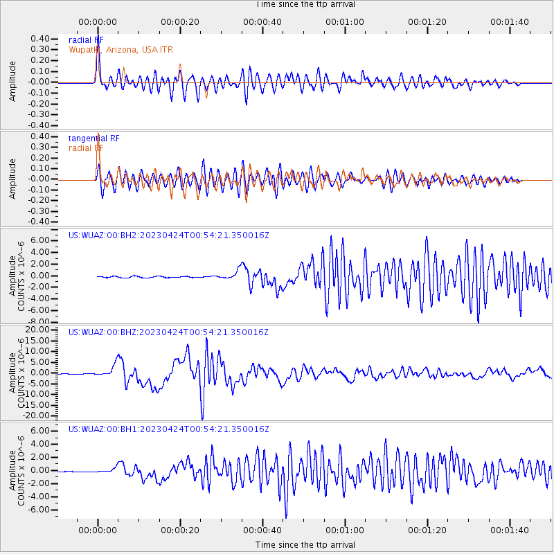
Signal To Noise
| Channel | StoN | STA | LTA |
| US:WUAZ:00:BHZ:20230424T00:54:21.350016Z | 35.196587 | 2.9699956E-6 | 8.438307E-8 |
| US:WUAZ:00:BH1:20230424T00:54:21.350016Z | 5.65338 | 3.8102309E-7 | 6.7397394E-8 |
| US:WUAZ:00:BH2:20230424T00:54:21.350016Z | 7.275201 | 8.234175E-7 | 1.13181414E-7 |
| Arrivals |
| Ps | 5.2 SECOND |
| PpPs | 19 SECOND |
| PsPs/PpSs | 24 SECOND |


