You are here: Home > Network List > UW - Pacific Northwest Regional Seismic Network Stations List
> Station RPW2 RPW2, Rockport WA > Earthquake Result Viewer
RPW2 RPW2, Rockport WA - Earthquake Result Viewer
| Earthquake location: |
Kermadec Islands, New Zealand |
| Earthquake latitude/longitude: |
-30.0/-177.9 |
| Earthquake time(UTC): |
2023/04/24 (114) 00:41:54 GMT |
| Earthquake Depth: |
34 km |
| Earthquake Magnitude: |
7.3 mww |
| Earthquake Catalog/Contributor: |
NEIC PDE/us |
|
| Network: |
UW Pacific Northwest Regional Seismic Network |
| Station: |
RPW2 RPW2, Rockport WA |
| Lat/Lon: |
48.44 N/121.53 W |
| Elevation: |
694 m |
|
| Distance: |
93.0 deg |
| Az: |
33.72 deg |
| Baz: |
226.309 deg |
| Ray Param: |
0.041352578 |
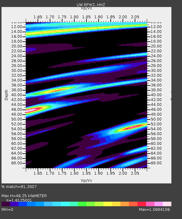
| Estimated Moho Depth: |
46.25 km |
| Estimated Crust Vp/Vs: |
1.61 |
| Assumed Crust Vp: |
6.566 km/s |
| Estimated Crust Vs: |
4.072 km/s |
| Estimated Crust Poisson's Ratio: |
0.19 |
|
| Radial Match: |
91.2807 % |
| Radial Bump: |
400 |
| Transverse Match: |
79.385475 % |
| Transverse Bump: |
400 |
| SOD ConfigId: |
30536071 |
| Insert Time: |
2023-05-08 01:33:32.967 +0000 |
| GWidth: |
2.5 |
| Max Bumps: |
400 |
| Tol: |
0.001 |
|

Signal To Noise
| Channel | StoN | STA | LTA |
| UW:RPW2: :HHZ:20230424T00:54:33.389994Z | 19.592299 | 3.7119835E-6 | 1.8946135E-7 |
| UW:RPW2: :HHN:20230424T00:54:33.389994Z | 8.39832 | 9.23709E-7 | 1.09987354E-7 |
| UW:RPW2: :HHE:20230424T00:54:33.389994Z | 4.631354 | 7.4215234E-7 | 1.6024522E-7 |
| Arrivals |
| Ps | 4.4 SECOND |
| PpPs | 18 SECOND |
| PsPs/PpSs | 22 SECOND |


