You are here: Home > Network List > AK - Alaska Regional Network Stations List
> Station D20K Etivluk River, AK, USA > Earthquake Result Viewer
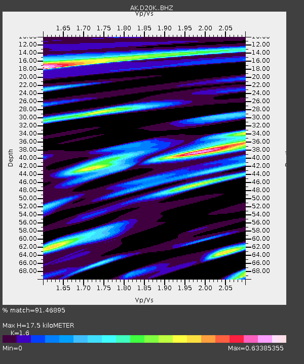
D20K Etivluk River, AK, USA - Earthquake Result Viewer
| Earthquake location: |
Southern Sumatra, Indonesia |
| Earthquake latitude/longitude: |
-0.8/98.5 |
| Earthquake time(UTC): |
2023/04/24 (114) 20:00:55 GMT |
| Earthquake Depth: |
15 km |
| Earthquake Magnitude: |
7.1 Mww |
| Earthquake Catalog/Contributor: |
NEIC PDE/us |
|
| Network: |
AK Alaska Regional Network |
| Station: |
D20K Etivluk River, AK, USA |
| Lat/Lon: |
68.71 N/156.61 W |
| Elevation: |
577 m |
|
| Distance: |
96.1 deg |
| Az: |
20.791 deg |
| Baz: |
283.592 deg |
| Ray Param: |
0.04061008 |
| Estimated Moho Depth: |
17.5 km |
| Estimated Crust Vp/Vs: |
1.60 |
| Assumed Crust Vp: |
6.221 km/s |
| Estimated Crust Vs: |
3.888 km/s |
| Estimated Crust Poisson's Ratio: |
0.18 |
|
| Radial Match: |
91.46895 % |
| Radial Bump: |
400 |
| Transverse Match: |
82.05092 % |
| Transverse Bump: |
400 |
| SOD ConfigId: |
30536071 |
| Insert Time: |
2023-05-08 20:03:02.305 +0000 |
| GWidth: |
2.5 |
| Max Bumps: |
400 |
| Tol: |
0.001 |
|

Signal To Noise
| Channel | StoN | STA | LTA |
| AK:D20K: :BHZ:20230424T20:13:50.140016Z | 5.93354 | 4.991585E-7 | 8.4124906E-8 |
| AK:D20K: :BHN:20230424T20:13:50.140016Z | 0.5296428 | 5.5284623E-8 | 1.0438095E-7 |
| AK:D20K: :BHE:20230424T20:13:50.140016Z | 1.5282283 | 1.9455358E-7 | 1.2730662E-7 |
| Arrivals |
| Ps | 1.7 SECOND |
| PpPs | 7.2 SECOND |
| PsPs/PpSs | 8.9 SECOND |


