You are here: Home > Network List > AK - Alaska Regional Network Stations List
> Station F20K Avaraart Lake, AK, USA > Earthquake Result Viewer
F20K Avaraart Lake, AK, USA - Earthquake Result Viewer
| Earthquake location: |
Southern Sumatra, Indonesia |
| Earthquake latitude/longitude: |
-0.8/98.5 |
| Earthquake time(UTC): |
2023/04/24 (114) 20:00:55 GMT |
| Earthquake Depth: |
15 km |
| Earthquake Magnitude: |
7.1 Mww |
| Earthquake Catalog/Contributor: |
NEIC PDE/us |
|
| Network: |
AK Alaska Regional Network |
| Station: |
F20K Avaraart Lake, AK, USA |
| Lat/Lon: |
67.05 N/155.73 W |
| Elevation: |
136 m |
|
| Distance: |
96.8 deg |
| Az: |
22.344 deg |
| Baz: |
284.239 deg |
| Ray Param: |
0.040399708 |
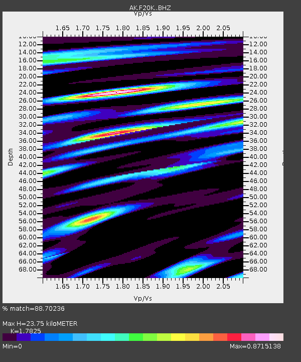
| Estimated Moho Depth: |
23.75 km |
| Estimated Crust Vp/Vs: |
1.78 |
| Assumed Crust Vp: |
6.522 km/s |
| Estimated Crust Vs: |
3.659 km/s |
| Estimated Crust Poisson's Ratio: |
0.27 |
|
| Radial Match: |
88.70236 % |
| Radial Bump: |
400 |
| Transverse Match: |
78.22824 % |
| Transverse Bump: |
400 |
| SOD ConfigId: |
30536071 |
| Insert Time: |
2023-05-08 20:03:13.932 +0000 |
| GWidth: |
2.5 |
| Max Bumps: |
400 |
| Tol: |
0.001 |
|

Signal To Noise
| Channel | StoN | STA | LTA |
| AK:F20K: :BHZ:20230424T20:13:53.419984Z | 3.5564964 | 3.4086594E-7 | 9.584319E-8 |
| AK:F20K: :BHN:20230424T20:13:53.419984Z | 1.3603787 | 9.362871E-8 | 6.882547E-8 |
| AK:F20K: :BHE:20230424T20:13:53.419984Z | 1.779748 | 1.487933E-7 | 8.360359E-8 |
| Arrivals |
| Ps | 2.9 SECOND |
| PpPs | 9.9 SECOND |
| PsPs/PpSs | 13 SECOND |


