You are here: Home > Network List > CH - Switzerland Seismological Network Stations List
> Station SENIN Lac Selin/Sanetsch > Earthquake Result Viewer
SENIN Lac Selin/Sanetsch - Earthquake Result Viewer
| Earthquake location: |
Southern Sumatra, Indonesia |
| Earthquake latitude/longitude: |
-0.8/98.5 |
| Earthquake time(UTC): |
2023/04/24 (114) 20:00:55 GMT |
| Earthquake Depth: |
15 km |
| Earthquake Magnitude: |
7.1 Mww |
| Earthquake Catalog/Contributor: |
NEIC PDE/us |
|
| Network: |
CH Switzerland Seismological Network |
| Station: |
SENIN Lac Selin/Sanetsch |
| Lat/Lon: |
46.36 N/7.30 E |
| Elevation: |
2035 m |
|
| Distance: |
91.4 deg |
| Az: |
316.167 deg |
| Baz: |
89.647 deg |
| Ray Param: |
0.041608613 |
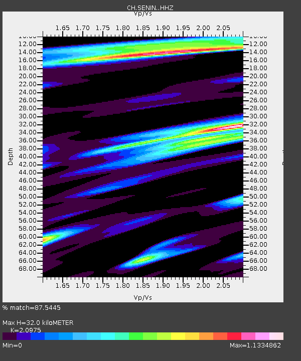
| Estimated Moho Depth: |
32.0 km |
| Estimated Crust Vp/Vs: |
2.10 |
| Assumed Crust Vp: |
6.276 km/s |
| Estimated Crust Vs: |
2.992 km/s |
| Estimated Crust Poisson's Ratio: |
0.35 |
|
| Radial Match: |
87.5445 % |
| Radial Bump: |
400 |
| Transverse Match: |
86.774765 % |
| Transverse Bump: |
400 |
| SOD ConfigId: |
30536071 |
| Insert Time: |
2023-05-08 20:07:29.125 +0000 |
| GWidth: |
2.5 |
| Max Bumps: |
400 |
| Tol: |
0.001 |
|
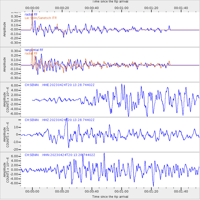
Signal To Noise
| Channel | StoN | STA | LTA |
| CH:SENIN: :HHZ:20230424T20:13:28.74402Z | 3.506676 | 1.4180854E-6 | 4.043959E-7 |
| CH:SENIN: :HHN:20230424T20:13:28.74402Z | 0.69087714 | 2.8988995E-7 | 4.1959697E-7 |
| CH:SENIN: :HHE:20230424T20:13:28.74402Z | 1.841115 | 8.777706E-7 | 4.7676036E-7 |
| Arrivals |
| Ps | 5.7 SECOND |
| PpPs | 16 SECOND |
| PsPs/PpSs | 21 SECOND |


