You are here: Home > Network List > TA - USArray Transportable Network (new EarthScope stations) Stations List
> Station L02D Cave Junction, OR, USA > Earthquake Result Viewer
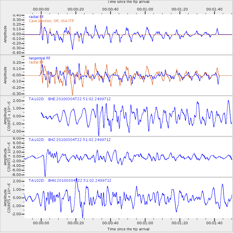
L02D Cave Junction, OR, USA - Earthquake Result Viewer
*The percent match for this event was below the threshold and hence no stack was calculated.
| Earthquake location: |
Northern Chile |
| Earthquake latitude/longitude: |
-22.2/-68.3 |
| Earthquake time(UTC): |
2010/03/04 (063) 22:39:26 GMT |
| Earthquake Depth: |
114 km |
| Earthquake Magnitude: |
6.3 MB, 6.4 MW, 6.3 MW |
| Earthquake Catalog/Contributor: |
WHDF/NEIC |
|
| Network: |
TA USArray Transportable Network (new EarthScope stations) |
| Station: |
L02D Cave Junction, OR, USA |
| Lat/Lon: |
42.16 N/123.60 W |
| Elevation: |
458 m |
|
| Distance: |
81.9 deg |
| Az: |
321.883 deg |
| Baz: |
129.715 deg |
| Ray Param: |
$rayparam |
*The percent match for this event was below the threshold and hence was not used in the summary stack. |
|
| Radial Match: |
76.130554 % |
| Radial Bump: |
400 |
| Transverse Match: |
66.08224 % |
| Transverse Bump: |
400 |
| SOD ConfigId: |
308276 |
| Insert Time: |
2010-06-22 17:14:07.666 +0000 |
| GWidth: |
2.5 |
| Max Bumps: |
400 |
| Tol: |
0.001 |
|
Signal To Noise
| Channel | StoN | STA | LTA |
| TA:L02D: :BHZ:20100304T22:51:02.249971Z | 7.1736555 | 3.1496568E-6 | 4.3905882E-7 |
| TA:L02D: :BHN:20100304T22:51:02.249971Z | 1.4628072 | 6.8596336E-7 | 4.689363E-7 |
| TA:L02D: :BHE:20100304T22:51:02.249971Z | 1.9474354 | 1.0424618E-6 | 5.352998E-7 |
| Arrivals |
| Ps | |
| PpPs | |
| PsPs/PpSs | |


