You are here: Home > Network List > KO - Kandilli Observatory Digital Broadband Seismic Network Stations List
> Station GURO KO.GURO > Earthquake Result Viewer
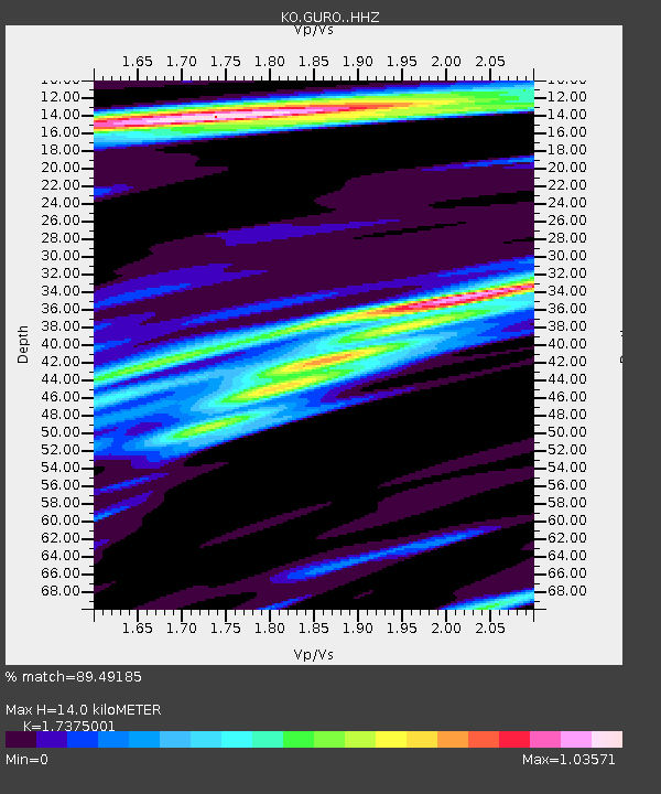
GURO KO.GURO - Earthquake Result Viewer
| Earthquake location: |
Southern Sumatra, Indonesia |
| Earthquake latitude/longitude: |
-0.8/98.5 |
| Earthquake time(UTC): |
2023/04/24 (114) 20:00:55 GMT |
| Earthquake Depth: |
15 km |
| Earthquake Magnitude: |
7.1 Mww |
| Earthquake Catalog/Contributor: |
NEIC PDE/us |
|
| Network: |
KO Kandilli Observatory Digital Broadband Seismic Network |
| Station: |
GURO KO.GURO |
| Lat/Lon: |
38.55 N/42.03 E |
| Elevation: |
1388 m |
|
| Distance: |
64.9 deg |
| Az: |
313.774 deg |
| Baz: |
112.953 deg |
| Ray Param: |
0.05862191 |
| Estimated Moho Depth: |
14.0 km |
| Estimated Crust Vp/Vs: |
1.74 |
| Assumed Crust Vp: |
6.35 km/s |
| Estimated Crust Vs: |
3.655 km/s |
| Estimated Crust Poisson's Ratio: |
0.25 |
|
| Radial Match: |
89.49185 % |
| Radial Bump: |
400 |
| Transverse Match: |
75.91341 % |
| Transverse Bump: |
400 |
| SOD ConfigId: |
30536071 |
| Insert Time: |
2023-05-08 20:11:34.057 +0000 |
| GWidth: |
2.5 |
| Max Bumps: |
400 |
| Tol: |
0.001 |
|

Signal To Noise
| Channel | StoN | STA | LTA |
| KO:GURO: :HHZ:20230424T20:11:02.419984Z | 9.346706 | 4.787729E-7 | 5.12237E-8 |
| KO:GURO: :HHN:20230424T20:11:02.419984Z | 0.41201246 | 1.8344849E-7 | 4.4524984E-7 |
| KO:GURO: :HHE:20230424T20:11:02.419984Z | 7.3011494 | 1.9686279E-7 | 2.696326E-8 |
| Arrivals |
| Ps | 1.7 SECOND |
| PpPs | 5.8 SECOND |
| PsPs/PpSs | 7.5 SECOND |


