You are here: Home > Network List > S1 - Australian Seismometers in Schools Stations List
> Station AUALC St Philip's College > Earthquake Result Viewer
AUALC St Philip's College - Earthquake Result Viewer
| Earthquake location: |
Southern Sumatra, Indonesia |
| Earthquake latitude/longitude: |
-0.8/98.5 |
| Earthquake time(UTC): |
2023/04/24 (114) 20:00:55 GMT |
| Earthquake Depth: |
15 km |
| Earthquake Magnitude: |
7.1 Mww |
| Earthquake Catalog/Contributor: |
NEIC PDE/us |
|
| Network: |
S1 Australian Seismometers in Schools |
| Station: |
AUALC St Philip's College |
| Lat/Lon: |
23.69 S/133.88 E |
| Elevation: |
573 m |
|
| Distance: |
41.1 deg |
| Az: |
126.283 deg |
| Baz: |
298.448 deg |
| Ray Param: |
0.07396192 |
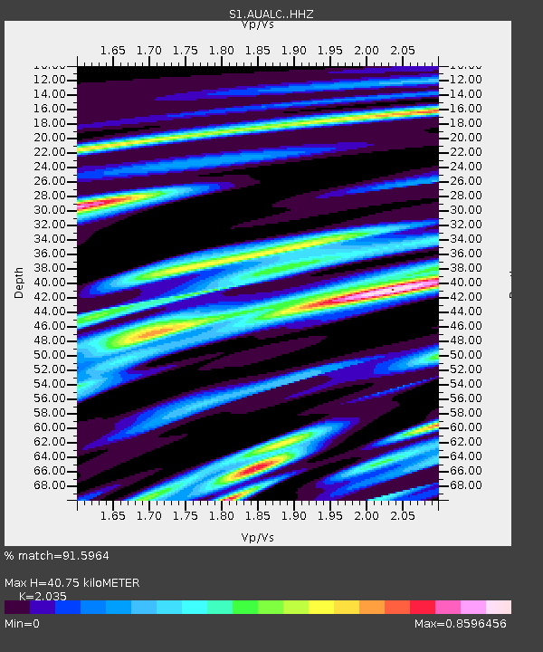
| Estimated Moho Depth: |
40.75 km |
| Estimated Crust Vp/Vs: |
2.04 |
| Assumed Crust Vp: |
6.518 km/s |
| Estimated Crust Vs: |
3.203 km/s |
| Estimated Crust Poisson's Ratio: |
0.34 |
|
| Radial Match: |
91.5964 % |
| Radial Bump: |
375 |
| Transverse Match: |
81.67087 % |
| Transverse Bump: |
400 |
| SOD ConfigId: |
30536071 |
| Insert Time: |
2023-05-08 20:14:01.618 +0000 |
| GWidth: |
2.5 |
| Max Bumps: |
400 |
| Tol: |
0.001 |
|

Signal To Noise
| Channel | StoN | STA | LTA |
| S1:AUALC: :HHZ:20230424T20:08:07.649995Z | 2.8637078 | 9.92976E-7 | 3.4674488E-7 |
| S1:AUALC: :HHN:20230424T20:08:07.649995Z | 1.1596637 | 3.42352E-7 | 2.952166E-7 |
| S1:AUALC: :HHE:20230424T20:08:07.649995Z | 2.7892897 | 7.610628E-7 | 2.7285182E-7 |
| Arrivals |
| Ps | 6.9 SECOND |
| PpPs | 18 SECOND |
| PsPs/PpSs | 25 SECOND |


