You are here: Home > Network List > TA - USArray Transportable Network (new EarthScope stations) Stations List
> Station 234A Clairette, TX, USA > Earthquake Result Viewer
234A Clairette, TX, USA - Earthquake Result Viewer
| Earthquake location: |
Northern Chile |
| Earthquake latitude/longitude: |
-22.2/-68.3 |
| Earthquake time(UTC): |
2010/03/04 (063) 22:39:26 GMT |
| Earthquake Depth: |
114 km |
| Earthquake Magnitude: |
6.3 MB, 6.4 MW, 6.3 MW |
| Earthquake Catalog/Contributor: |
WHDF/NEIC |
|
| Network: |
TA USArray Transportable Network (new EarthScope stations) |
| Station: |
234A Clairette, TX, USA |
| Lat/Lon: |
32.00 N/98.14 W |
| Elevation: |
358 m |
|
| Distance: |
61.0 deg |
| Az: |
331.128 deg |
| Baz: |
148.224 deg |
| Ray Param: |
0.060827807 |
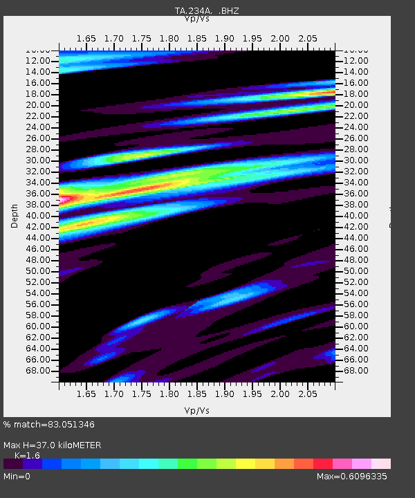
| Estimated Moho Depth: |
37.0 km |
| Estimated Crust Vp/Vs: |
1.60 |
| Assumed Crust Vp: |
6.426 km/s |
| Estimated Crust Vs: |
4.016 km/s |
| Estimated Crust Poisson's Ratio: |
0.18 |
|
| Radial Match: |
83.051346 % |
| Radial Bump: |
358 |
| Transverse Match: |
73.27712 % |
| Transverse Bump: |
400 |
| SOD ConfigId: |
308276 |
| Insert Time: |
2010-06-22 17:15:08.890 +0000 |
| GWidth: |
2.5 |
| Max Bumps: |
400 |
| Tol: |
0.001 |
|

Signal To Noise
| Channel | StoN | STA | LTA |
| TA:234A: :BHZ:20100304T22:48:57.249971Z | 28.685812 | 5.985529E-6 | 2.0865816E-7 |
| TA:234A: :BHN:20100304T22:48:57.249971Z | 7.273154 | 2.063786E-6 | 2.8375393E-7 |
| TA:234A: :BHE:20100304T22:48:57.249971Z | 5.215002 | 1.4161285E-6 | 2.7154897E-7 |
| Arrivals |
| Ps | 3.6 SECOND |
| PpPs | 14 SECOND |
| PsPs/PpSs | 18 SECOND |


