You are here: Home > Network List > UW - Pacific Northwest Regional Seismic Network Stations List
> Station UMAT Pilot Rock, OR, USA > Earthquake Result Viewer
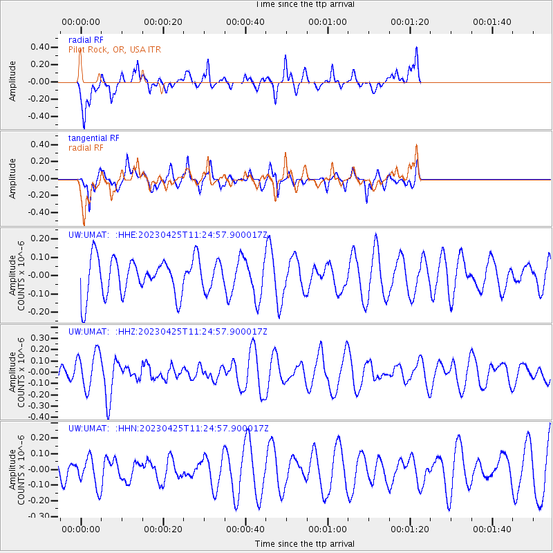
UMAT Pilot Rock, OR, USA - Earthquake Result Viewer
*The percent match for this event was below the threshold and hence no stack was calculated.
| Earthquake location: |
West Chile Rise |
| Earthquake latitude/longitude: |
-41.3/-86.2 |
| Earthquake time(UTC): |
2023/04/25 (115) 11:12:24 GMT |
| Earthquake Depth: |
10 km |
| Earthquake Magnitude: |
5.5 mww |
| Earthquake Catalog/Contributor: |
NEIC PDE/us |
|
| Network: |
UW Pacific Northwest Regional Seismic Network |
| Station: |
UMAT Pilot Rock, OR, USA |
| Lat/Lon: |
45.29 N/118.96 W |
| Elevation: |
1318 m |
|
| Distance: |
91.1 deg |
| Az: |
337.561 deg |
| Baz: |
155.976 deg |
| Ray Param: |
$rayparam |
*The percent match for this event was below the threshold and hence was not used in the summary stack. |
|
| Radial Match: |
67.442 % |
| Radial Bump: |
391 |
| Transverse Match: |
67.85266 % |
| Transverse Bump: |
400 |
| SOD ConfigId: |
30536071 |
| Insert Time: |
2023-05-09 11:31:34.626 +0000 |
| GWidth: |
2.5 |
| Max Bumps: |
400 |
| Tol: |
0.001 |
|
Signal To Noise
| Channel | StoN | STA | LTA |
| UW:UMAT: :HHZ:20230425T11:24:57.900017Z | 1.9596751 | 1.6755767E-7 | 8.550278E-8 |
| UW:UMAT: :HHN:20230425T11:24:57.900017Z | 0.88125354 | 9.311367E-8 | 1.05660476E-7 |
| UW:UMAT: :HHE:20230425T11:24:57.900017Z | 0.69155324 | 7.131447E-8 | 1.0312217E-7 |
| Arrivals |
| Ps | |
| PpPs | |
| PsPs/PpSs | |


