You are here: Home > Network List > TA - USArray Transportable Network (new EarthScope stations) Stations List
> Station 436A Wall Ranch, Gause, TX, USA > Earthquake Result Viewer
436A Wall Ranch, Gause, TX, USA - Earthquake Result Viewer
| Earthquake location: |
Northern Chile |
| Earthquake latitude/longitude: |
-22.2/-68.3 |
| Earthquake time(UTC): |
2010/03/04 (063) 22:39:26 GMT |
| Earthquake Depth: |
114 km |
| Earthquake Magnitude: |
6.3 MB, 6.4 MW, 6.3 MW |
| Earthquake Catalog/Contributor: |
WHDF/NEIC |
|
| Network: |
TA USArray Transportable Network (new EarthScope stations) |
| Station: |
436A Wall Ranch, Gause, TX, USA |
| Lat/Lon: |
30.77 N/96.80 W |
| Elevation: |
109 m |
|
| Distance: |
59.4 deg |
| Az: |
331.52 deg |
| Baz: |
149.114 deg |
| Ray Param: |
0.06190221 |
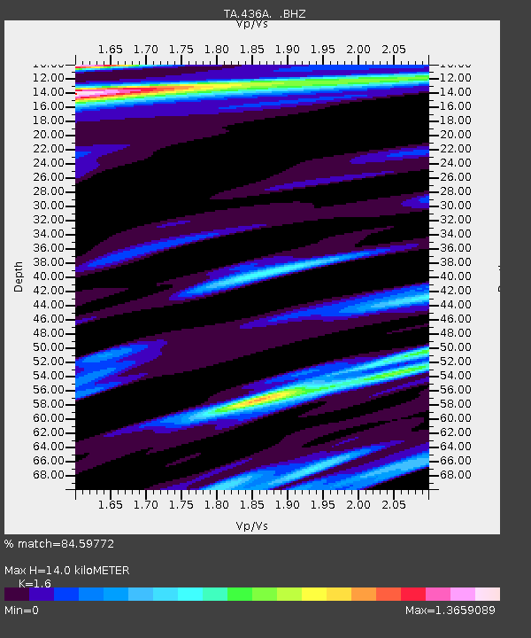
| Estimated Moho Depth: |
14.0 km |
| Estimated Crust Vp/Vs: |
1.60 |
| Assumed Crust Vp: |
6.347 km/s |
| Estimated Crust Vs: |
3.967 km/s |
| Estimated Crust Poisson's Ratio: |
0.18 |
|
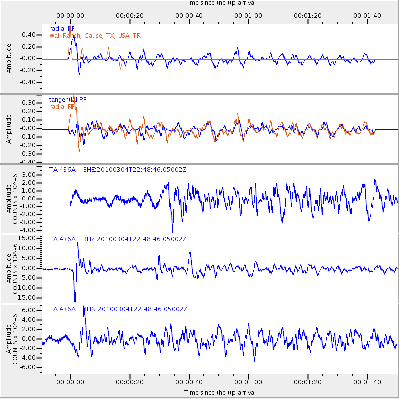
| Radial Match: |
84.59772 % |
| Radial Bump: |
400 |
| Transverse Match: |
60.57648 % |
| Transverse Bump: |
400 |
| SOD ConfigId: |
308276 |
| Insert Time: |
2010-06-22 17:16:50.425 +0000 |
| GWidth: |
2.5 |
| Max Bumps: |
400 |
| Tol: |
0.001 |
|
Signal To Noise
| Channel | StoN | STA | LTA |
| TA:436A: :BHZ:20100304T22:48:46.05002Z | 24.104912 | 6.3986827E-6 | 2.654514E-7 |
| TA:436A: :BHN:20100304T22:48:46.05002Z | 4.076176 | 2.5437466E-6 | 6.240522E-7 |
| TA:436A: :BHE:20100304T22:48:46.05002Z | 3.720171 | 1.5139593E-6 | 4.0695963E-7 |
| Arrivals |
| Ps | 1.4 SECOND |
| PpPs | 5.4 SECOND |
| PsPs/PpSs | 6.8 SECOND |


