You are here: Home > Network List > TA - USArray Transportable Network (new EarthScope stations) Stations List
> Station 337A Centerville, TX, USA > Earthquake Result Viewer
337A Centerville, TX, USA - Earthquake Result Viewer
| Earthquake location: |
Northern Chile |
| Earthquake latitude/longitude: |
-22.2/-68.3 |
| Earthquake time(UTC): |
2010/03/04 (063) 22:39:26 GMT |
| Earthquake Depth: |
114 km |
| Earthquake Magnitude: |
6.3 MB, 6.4 MW, 6.3 MW |
| Earthquake Catalog/Contributor: |
WHDF/NEIC |
|
| Network: |
TA USArray Transportable Network (new EarthScope stations) |
| Station: |
337A Centerville, TX, USA |
| Lat/Lon: |
31.32 N/95.89 W |
| Elevation: |
150 m |
|
| Distance: |
59.4 deg |
| Az: |
332.623 deg |
| Baz: |
150.142 deg |
| Ray Param: |
0.061854187 |
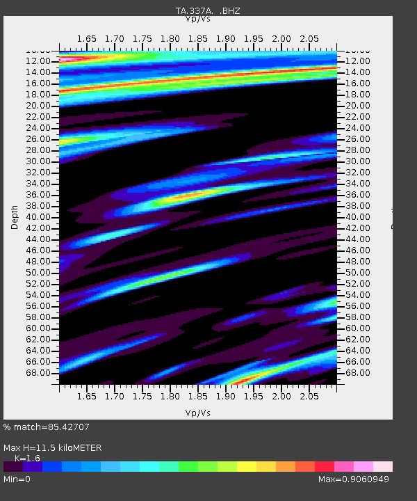
| Estimated Moho Depth: |
11.5 km |
| Estimated Crust Vp/Vs: |
1.60 |
| Assumed Crust Vp: |
5.738 km/s |
| Estimated Crust Vs: |
3.587 km/s |
| Estimated Crust Poisson's Ratio: |
0.18 |
|
| Radial Match: |
85.42707 % |
| Radial Bump: |
400 |
| Transverse Match: |
61.82676 % |
| Transverse Bump: |
400 |
| SOD ConfigId: |
308276 |
| Insert Time: |
2010-06-22 17:17:03.813 +0000 |
| GWidth: |
2.5 |
| Max Bumps: |
400 |
| Tol: |
0.001 |
|
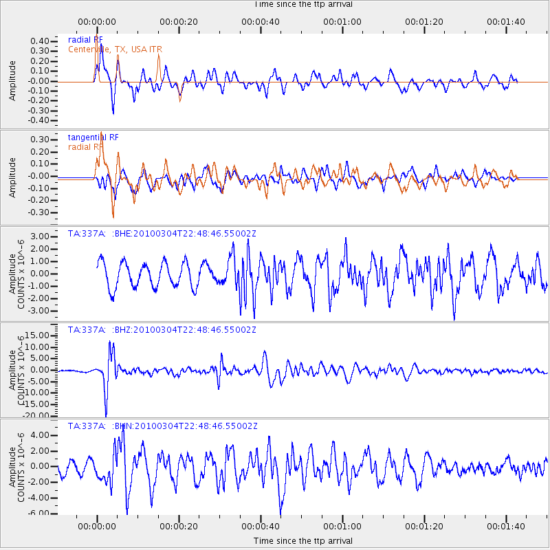
Signal To Noise
| Channel | StoN | STA | LTA |
| TA:337A: :BHZ:20100304T22:48:46.55002Z | 23.37301 | 7.697163E-6 | 3.2931842E-7 |
| TA:337A: :BHN:20100304T22:48:46.55002Z | 2.737809 | 1.7014992E-6 | 6.2148206E-7 |
| TA:337A: :BHE:20100304T22:48:46.55002Z | 1.142353 | 1.1255281E-6 | 9.852716E-7 |
| Arrivals |
| Ps | 1.3 SECOND |
| PpPs | 5.0 SECOND |
| PsPs/PpSs | 6.3 SECOND |


