You are here: Home > Network List > IW - Intermountain West Stations List
> Station MOOW Moose Ponds, Wyoming, USA > Earthquake Result Viewer
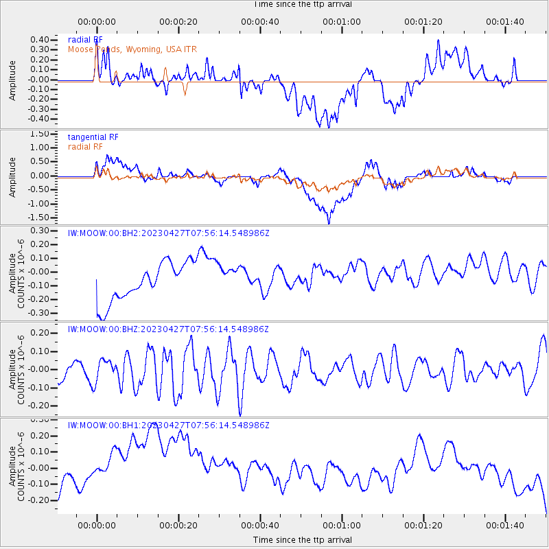
MOOW Moose Ponds, Wyoming, USA - Earthquake Result Viewer
*The percent match for this event was below the threshold and hence no stack was calculated.
| Earthquake location: |
Ryukyu Islands, Japan |
| Earthquake latitude/longitude: |
26.1/128.6 |
| Earthquake time(UTC): |
2023/04/27 (117) 07:43:38 GMT |
| Earthquake Depth: |
10 km |
| Earthquake Magnitude: |
5.3 Mww |
| Earthquake Catalog/Contributor: |
NEIC PDE/us |
|
| Network: |
IW Intermountain West |
| Station: |
MOOW Moose Ponds, Wyoming, USA |
| Lat/Lon: |
43.75 N/110.74 W |
| Elevation: |
2128 m |
|
| Distance: |
91.8 deg |
| Az: |
38.568 deg |
| Baz: |
309.312 deg |
| Ray Param: |
$rayparam |
*The percent match for this event was below the threshold and hence was not used in the summary stack. |
|
| Radial Match: |
21.821056 % |
| Radial Bump: |
400 |
| Transverse Match: |
21.500284 % |
| Transverse Bump: |
400 |
| SOD ConfigId: |
30536071 |
| Insert Time: |
2023-05-11 07:57:52.039 +0000 |
| GWidth: |
2.5 |
| Max Bumps: |
400 |
| Tol: |
0.001 |
|
Signal To Noise
| Channel | StoN | STA | LTA |
| IW:MOOW:00:BHZ:20230427T07:56:14.548986Z | 1.8002237 | 6.011347E-8 | 3.3392222E-8 |
| IW:MOOW:00:BH1:20230427T07:56:14.548986Z | 1.3157111 | 4.3894738E-7 | 3.3361988E-7 |
| IW:MOOW:00:BH2:20230427T07:56:14.548986Z | 0.7443984 | 1.03561064E-7 | 1.3912049E-7 |
| Arrivals |
| Ps | |
| PpPs | |
| PsPs/PpSs | |


