You are here: Home > Network List > US - United States National Seismic Network Stations List
> Station AMTX Amarillo, Texas, USA > Earthquake Result Viewer
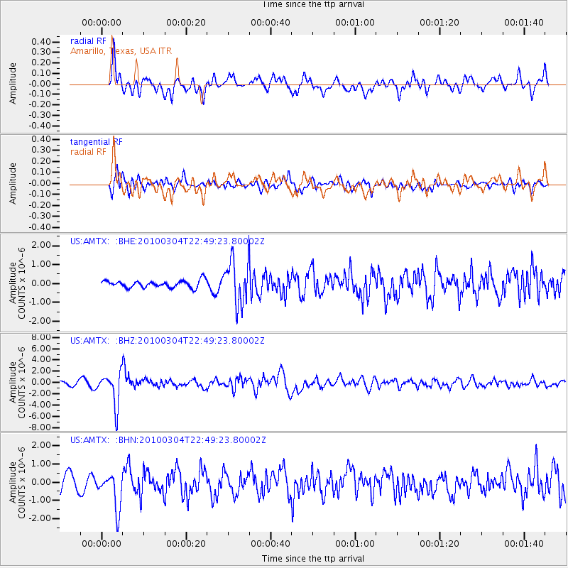
AMTX Amarillo, Texas, USA - Earthquake Result Viewer
*The percent match for this event was below the threshold and hence no stack was calculated.
| Earthquake location: |
Northern Chile |
| Earthquake latitude/longitude: |
-22.2/-68.3 |
| Earthquake time(UTC): |
2010/03/04 (063) 22:39:26 GMT |
| Earthquake Depth: |
114 km |
| Earthquake Magnitude: |
6.3 MB, 6.4 MW, 6.3 MW |
| Earthquake Catalog/Contributor: |
WHDF/NEIC |
|
| Network: |
US United States National Seismic Network |
| Station: |
AMTX Amarillo, Texas, USA |
| Lat/Lon: |
34.53 N/101.41 W |
| Elevation: |
1010 m |
|
| Distance: |
64.6 deg |
| Az: |
330.079 deg |
| Baz: |
145.957 deg |
| Ray Param: |
$rayparam |
*The percent match for this event was below the threshold and hence was not used in the summary stack. |
|
| Radial Match: |
71.0377 % |
| Radial Bump: |
400 |
| Transverse Match: |
69.910126 % |
| Transverse Bump: |
400 |
| SOD ConfigId: |
308276 |
| Insert Time: |
2010-06-22 17:21:20.370 +0000 |
| GWidth: |
2.5 |
| Max Bumps: |
400 |
| Tol: |
0.001 |
|
Signal To Noise
| Channel | StoN | STA | LTA |
| US:AMTX: :BHZ:20100304T22:49:23.80002Z | 9.977611 | 2.9199055E-6 | 2.9264575E-7 |
| US:AMTX: :BHN:20100304T22:49:23.80002Z | 2.963616 | 1.0526835E-6 | 3.5520242E-7 |
| US:AMTX: :BHE:20100304T22:49:23.80002Z | 6.4207854 | 9.4677745E-7 | 1.4745508E-7 |
| Arrivals |
| Ps | |
| PpPs | |
| PsPs/PpSs | |


