You are here: Home > Network List > IW - Intermountain West Stations List
> Station DLMT Dillon, Montana, USA > Earthquake Result Viewer
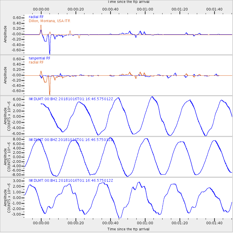
DLMT Dillon, Montana, USA - Earthquake Result Viewer
*The percent match for this event was below the threshold and hence no stack was calculated.
| Earthquake location: |
Southeast Of Loyalty Islands |
| Earthquake latitude/longitude: |
-21.7/169.4 |
| Earthquake time(UTC): |
2018/10/16 (289) 01:03:46 GMT |
| Earthquake Depth: |
10 km |
| Earthquake Magnitude: |
6.8 Mi |
| Earthquake Catalog/Contributor: |
NEIC PDE/at |
|
| Network: |
IW Intermountain West |
| Station: |
DLMT Dillon, Montana, USA |
| Lat/Lon: |
45.36 N/112.60 W |
| Elevation: |
1569 m |
|
| Distance: |
97.1 deg |
| Az: |
44.016 deg |
| Baz: |
246.423 deg |
| Ray Param: |
$rayparam |
*The percent match for this event was below the threshold and hence was not used in the summary stack. |
|
| Radial Match: |
94.83877 % |
| Radial Bump: |
370 |
| Transverse Match: |
78.349266 % |
| Transverse Bump: |
400 |
| SOD ConfigId: |
3045211 |
| Insert Time: |
2018-10-30 01:27:26.708 +0000 |
| GWidth: |
2.5 |
| Max Bumps: |
400 |
| Tol: |
0.001 |
|
Signal To Noise
| Channel | StoN | STA | LTA |
| IW:DLMT:00:BHZ:20181016T01:16:46.575012Z | 1.1882648 | 5.1147613E-6 | 4.3043947E-6 |
| IW:DLMT:00:BH1:20181016T01:16:46.575012Z | 1.5960281 | 2.2122913E-6 | 1.3861231E-6 |
| IW:DLMT:00:BH2:20181016T01:16:46.575012Z | 1.4864042 | 5.319177E-6 | 3.5785538E-6 |
| Arrivals |
| Ps | |
| PpPs | |
| PsPs/PpSs | |


