You are here: Home > Network List > UW - Pacific Northwest Regional Seismic Network Stations List
> Station UMAT Pilot Rock, OR, USA > Earthquake Result Viewer
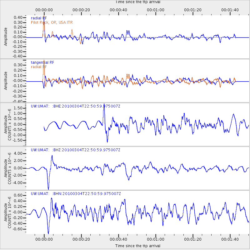
UMAT Pilot Rock, OR, USA - Earthquake Result Viewer
*The percent match for this event was below the threshold and hence no stack was calculated.
| Earthquake location: |
Northern Chile |
| Earthquake latitude/longitude: |
-22.2/-68.3 |
| Earthquake time(UTC): |
2010/03/04 (063) 22:39:26 GMT |
| Earthquake Depth: |
114 km |
| Earthquake Magnitude: |
6.3 MB, 6.4 MW, 6.3 MW |
| Earthquake Catalog/Contributor: |
WHDF/NEIC |
|
| Network: |
UW Pacific Northwest Regional Seismic Network |
| Station: |
UMAT Pilot Rock, OR, USA |
| Lat/Lon: |
45.29 N/118.96 W |
| Elevation: |
1318 m |
|
| Distance: |
81.5 deg |
| Az: |
326.507 deg |
| Baz: |
133.585 deg |
| Ray Param: |
$rayparam |
*The percent match for this event was below the threshold and hence was not used in the summary stack. |
|
| Radial Match: |
68.016174 % |
| Radial Bump: |
400 |
| Transverse Match: |
67.389404 % |
| Transverse Bump: |
400 |
| SOD ConfigId: |
308276 |
| Insert Time: |
2010-06-22 17:23:43.529 +0000 |
| GWidth: |
2.5 |
| Max Bumps: |
400 |
| Tol: |
0.001 |
|
Signal To Noise
| Channel | StoN | STA | LTA |
| UW:UMAT: :BHZ:20100304T22:50:59.975007Z | 14.742322 | 2.3154505E-6 | 1.5706145E-7 |
| UW:UMAT: :BHN:20100304T22:50:59.975007Z | 4.5830274 | 3.3473066E-7 | 7.303702E-8 |
| UW:UMAT: :BHE:20100304T22:50:59.975007Z | 3.3692086 | 8.4994196E-7 | 2.5226754E-7 |
| Arrivals |
| Ps | |
| PpPs | |
| PsPs/PpSs | |


