You are here: Home > Network List > AU - Australian Seismological Centre Stations List
> Station KIM01 GSWA station > Earthquake Result Viewer
KIM01 GSWA station - Earthquake Result Viewer
| Earthquake location: |
South Of Fiji Islands |
| Earthquake latitude/longitude: |
-25.1/178.5 |
| Earthquake time(UTC): |
2023/04/28 (118) 03:13:43 GMT |
| Earthquake Depth: |
577 km |
| Earthquake Magnitude: |
6.2 mb |
| Earthquake Catalog/Contributor: |
NEIC PDE/us |
|
| Network: |
AU Australian Seismological Centre |
| Station: |
KIM01 GSWA station |
| Lat/Lon: |
18.62 S/126.86 E |
| Elevation: |
314 m |
|
| Distance: |
48.1 deg |
| Az: |
266.983 deg |
| Baz: |
107.312 deg |
| Ray Param: |
0.066842444 |
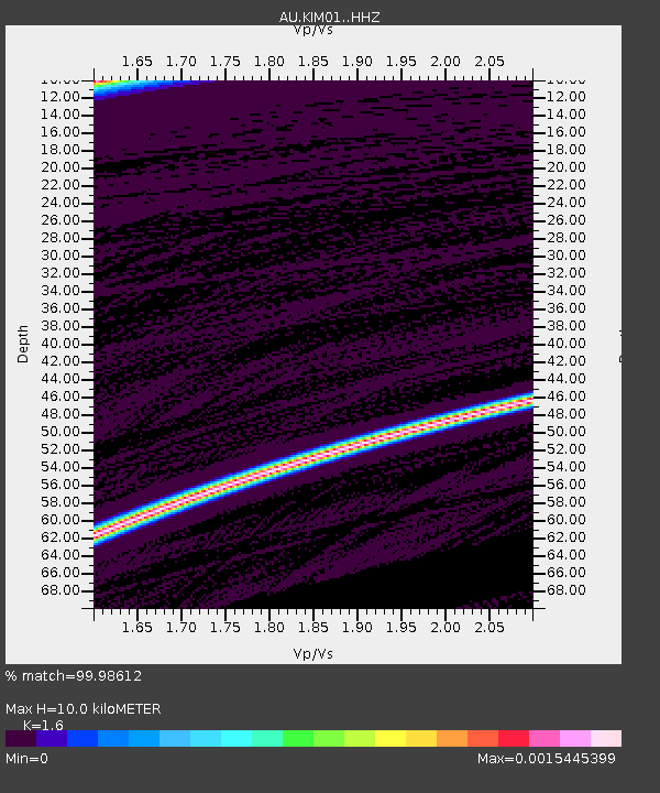
| Estimated Moho Depth: |
10.0 km |
| Estimated Crust Vp/Vs: |
1.60 |
| Assumed Crust Vp: |
6.496 km/s |
| Estimated Crust Vs: |
4.06 km/s |
| Estimated Crust Poisson's Ratio: |
0.18 |
|
| Radial Match: |
99.98612 % |
| Radial Bump: |
2 |
| Transverse Match: |
99.98612 % |
| Transverse Bump: |
2 |
| SOD ConfigId: |
30536071 |
| Insert Time: |
2023-05-12 03:18:42.559 +0000 |
| GWidth: |
2.5 |
| Max Bumps: |
400 |
| Tol: |
0.001 |
|

Signal To Noise
| Channel | StoN | STA | LTA |
| AU:KIM01: :HHZ:20230428T03:21:01.345011Z | 16.008396 | 5.4482502E-6 | 3.4033704E-7 |
| $trig.getChannelId() | $trig.getValue() | $trig.getSTA() | $trig.getLTA() |
| AU:KIM01: :HHE:20230428T03:21:01.345011Z | 16.060492 | 7.733659E-6 | 4.8153316E-7 |
| Arrivals |
| Ps | 1.0 SECOND |
| PpPs | 3.8 SECOND |
| PsPs/PpSs | 4.7 SECOND |


