You are here: Home > Network List > AU - Australian Seismological Centre Stations List
> Station KLBR Kellerberrin, Western Australia > Earthquake Result Viewer
KLBR Kellerberrin, Western Australia - Earthquake Result Viewer
| Earthquake location: |
South Of Fiji Islands |
| Earthquake latitude/longitude: |
-25.1/178.5 |
| Earthquake time(UTC): |
2023/04/28 (118) 03:13:43 GMT |
| Earthquake Depth: |
577 km |
| Earthquake Magnitude: |
6.2 mb |
| Earthquake Catalog/Contributor: |
NEIC PDE/us |
|
| Network: |
AU Australian Seismological Centre |
| Station: |
KLBR Kellerberrin, Western Australia |
| Lat/Lon: |
31.59 S/117.75 E |
| Elevation: |
320 m |
|
| Distance: |
53.2 deg |
| Az: |
248.285 deg |
| Baz: |
99.26 deg |
| Ray Param: |
0.063680634 |
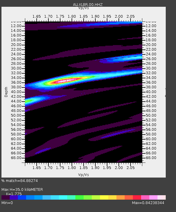
| Estimated Moho Depth: |
35.0 km |
| Estimated Crust Vp/Vs: |
1.77 |
| Assumed Crust Vp: |
6.419 km/s |
| Estimated Crust Vs: |
3.616 km/s |
| Estimated Crust Poisson's Ratio: |
0.27 |
|
| Radial Match: |
84.88274 % |
| Radial Bump: |
396 |
| Transverse Match: |
65.58976 % |
| Transverse Bump: |
400 |
| SOD ConfigId: |
30536071 |
| Insert Time: |
2023-05-12 03:18:48.923 +0000 |
| GWidth: |
2.5 |
| Max Bumps: |
400 |
| Tol: |
0.001 |
|

Signal To Noise
| Channel | StoN | STA | LTA |
| AU:KLBR:00:HHZ:20230428T03:21:38.595011Z | 26.282385 | 1.3841981E-5 | 5.266638E-7 |
| AU:KLBR:00:HHN:20230428T03:21:38.595011Z | 4.2851157 | 1.3316188E-6 | 3.1075444E-7 |
| AU:KLBR:00:HHE:20230428T03:21:38.595011Z | 17.839056 | 6.722742E-6 | 3.768553E-7 |
| Arrivals |
| Ps | 4.4 SECOND |
| PpPs | 14 SECOND |
| PsPs/PpSs | 19 SECOND |


