You are here: Home > Network List > AV - Alaska Volcano Observatory Stations List
> Station ADAG Mount Adagdak, Regional Station, Alaska > Earthquake Result Viewer
ADAG Mount Adagdak, Regional Station, Alaska - Earthquake Result Viewer
| Earthquake location: |
South Of Fiji Islands |
| Earthquake latitude/longitude: |
-25.1/178.5 |
| Earthquake time(UTC): |
2023/04/28 (118) 03:13:43 GMT |
| Earthquake Depth: |
577 km |
| Earthquake Magnitude: |
6.2 mb |
| Earthquake Catalog/Contributor: |
NEIC PDE/us |
|
| Network: |
AV Alaska Volcano Observatory |
| Station: |
ADAG Mount Adagdak, Regional Station, Alaska |
| Lat/Lon: |
51.98 N/176.60 W |
| Elevation: |
281 m |
|
| Distance: |
76.9 deg |
| Az: |
3.133 deg |
| Baz: |
184.595 deg |
| Ray Param: |
0.04887523 |
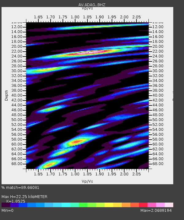
| Estimated Moho Depth: |
22.25 km |
| Estimated Crust Vp/Vs: |
1.85 |
| Assumed Crust Vp: |
5.88 km/s |
| Estimated Crust Vs: |
3.174 km/s |
| Estimated Crust Poisson's Ratio: |
0.29 |
|
| Radial Match: |
89.66081 % |
| Radial Bump: |
400 |
| Transverse Match: |
82.58486 % |
| Transverse Bump: |
400 |
| SOD ConfigId: |
30536071 |
| Insert Time: |
2023-05-12 03:19:36.858 +0000 |
| GWidth: |
2.5 |
| Max Bumps: |
400 |
| Tol: |
0.001 |
|
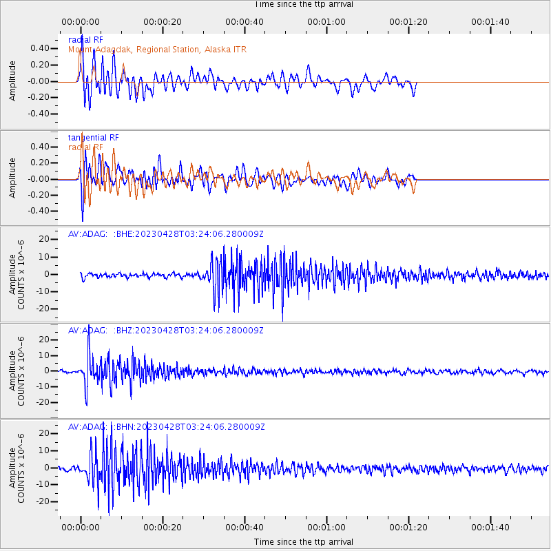
Signal To Noise
| Channel | StoN | STA | LTA |
| AV:ADAG: :BHZ:20230428T03:24:06.280009Z | 16.58383 | 9.6764925E-6 | 5.834897E-7 |
| AV:ADAG: :BHN:20230428T03:24:06.280009Z | 9.279766 | 8.020316E-6 | 8.6427997E-7 |
| AV:ADAG: :BHE:20230428T03:24:06.280009Z | 7.6157746 | 8.168808E-6 | 1.0726168E-6 |
| Arrivals |
| Ps | 3.3 SECOND |
| PpPs | 11 SECOND |
| PsPs/PpSs | 14 SECOND |


