You are here: Home > Network List > TA - USArray Transportable Network (new EarthScope stations) Stations List
> Station 121A Cookes Peak, Deming, NM, USA > Earthquake Result Viewer
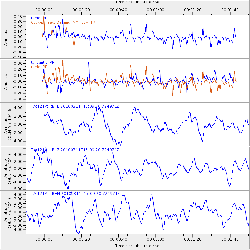
121A Cookes Peak, Deming, NM, USA - Earthquake Result Viewer
*The percent match for this event was below the threshold and hence no stack was calculated.
| Earthquake location: |
Near Coast Of Central Chile |
| Earthquake latitude/longitude: |
-34.6/-72.0 |
| Earthquake time(UTC): |
2010/03/11 (070) 14:58:15 GMT |
| Earthquake Depth: |
35 km |
| Earthquake Magnitude: |
5.6 MB |
| Earthquake Catalog/Contributor: |
WHDF/NEIC |
|
| Network: |
TA USArray Transportable Network (new EarthScope stations) |
| Station: |
121A Cookes Peak, Deming, NM, USA |
| Lat/Lon: |
32.53 N/107.79 W |
| Elevation: |
1652 m |
|
| Distance: |
74.8 deg |
| Az: |
329.202 deg |
| Baz: |
150.005 deg |
| Ray Param: |
$rayparam |
*The percent match for this event was below the threshold and hence was not used in the summary stack. |
|
| Radial Match: |
52.533745 % |
| Radial Bump: |
400 |
| Transverse Match: |
58.952984 % |
| Transverse Bump: |
400 |
| SOD ConfigId: |
308276 |
| Insert Time: |
2010-06-22 17:30:55.374 +0000 |
| GWidth: |
2.5 |
| Max Bumps: |
400 |
| Tol: |
0.001 |
|
Signal To Noise
| Channel | StoN | STA | LTA |
| TA:121A: :BHZ:20100311T15:09:20.724971Z | 2.5278466 | 4.546854E-6 | 1.7987066E-6 |
| TA:121A: :BHN:20100311T15:09:20.724971Z | 0.73040587 | 9.3371017E-7 | 1.2783444E-6 |
| TA:121A: :BHE:20100311T15:09:20.724971Z | 1.7371863 | 2.6425218E-6 | 1.5211505E-6 |
| Arrivals |
| Ps | |
| PpPs | |
| PsPs/PpSs | |


