You are here: Home > Network List > AV - Alaska Volcano Observatory Stations List
> Station KOKL Mount Kliuchef, Korovin Volcano, Alaska > Earthquake Result Viewer
KOKL Mount Kliuchef, Korovin Volcano, Alaska - Earthquake Result Viewer
| Earthquake location: |
South Of Fiji Islands |
| Earthquake latitude/longitude: |
-25.1/178.5 |
| Earthquake time(UTC): |
2023/04/28 (118) 03:13:43 GMT |
| Earthquake Depth: |
577 km |
| Earthquake Magnitude: |
6.2 mb |
| Earthquake Catalog/Contributor: |
NEIC PDE/us |
|
| Network: |
AV Alaska Volcano Observatory |
| Station: |
KOKL Mount Kliuchef, Korovin Volcano, Alaska |
| Lat/Lon: |
52.32 N/174.20 W |
| Elevation: |
758 m |
|
| Distance: |
77.4 deg |
| Az: |
4.607 deg |
| Baz: |
186.814 deg |
| Ray Param: |
0.04855975 |
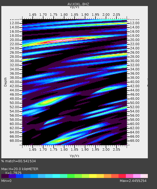
| Estimated Moho Depth: |
20.0 km |
| Estimated Crust Vp/Vs: |
1.79 |
| Assumed Crust Vp: |
5.88 km/s |
| Estimated Crust Vs: |
3.281 km/s |
| Estimated Crust Poisson's Ratio: |
0.27 |
|
| Radial Match: |
80.541534 % |
| Radial Bump: |
400 |
| Transverse Match: |
79.8057 % |
| Transverse Bump: |
400 |
| SOD ConfigId: |
30536071 |
| Insert Time: |
2023-05-12 03:21:36.468 +0000 |
| GWidth: |
2.5 |
| Max Bumps: |
400 |
| Tol: |
0.001 |
|

Signal To Noise
| Channel | StoN | STA | LTA |
| AV:KOKL: :BHZ:20230428T03:24:08.920023Z | 8.004945 | 5.5390383E-6 | 6.9195215E-7 |
| AV:KOKL: :BHN:20230428T03:24:08.920023Z | 4.9581227 | 6.064287E-6 | 1.2231014E-6 |
| AV:KOKL: :BHE:20230428T03:24:08.920023Z | 5.264404 | 4.5198076E-6 | 8.585602E-7 |
| Arrivals |
| Ps | 2.8 SECOND |
| PpPs | 9.3 SECOND |
| PsPs/PpSs | 12 SECOND |


