You are here: Home > Network List > AV - Alaska Volcano Observatory Stations List
> Station SPCR Ckakachatna River, Mount Spurr, Alaska > Earthquake Result Viewer
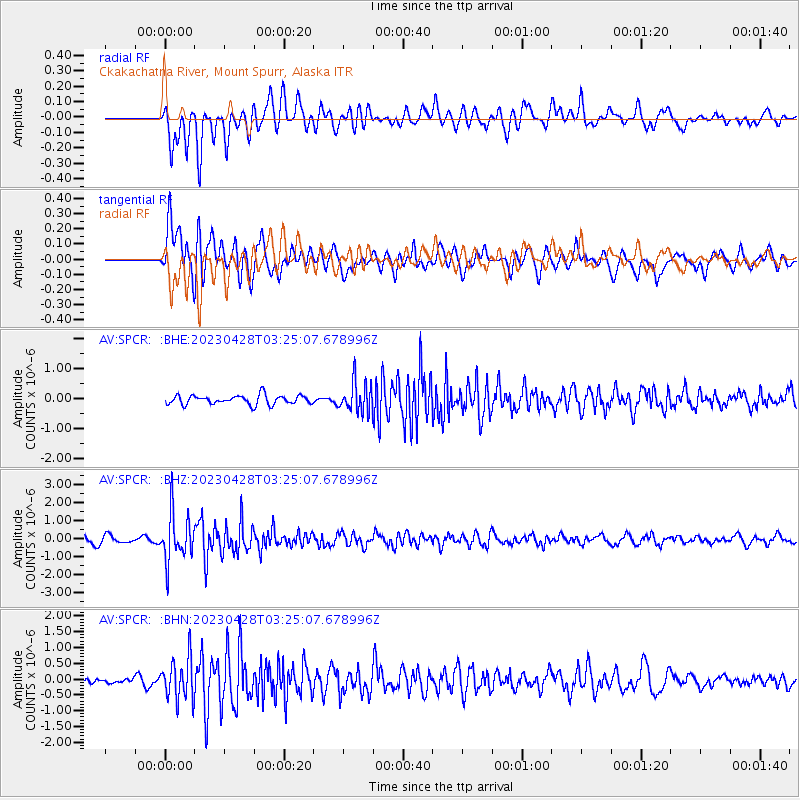
SPCR Ckakachatna River, Mount Spurr, Alaska - Earthquake Result Viewer
*The percent match for this event was below the threshold and hence no stack was calculated.
| Earthquake location: |
South Of Fiji Islands |
| Earthquake latitude/longitude: |
-25.1/178.5 |
| Earthquake time(UTC): |
2023/04/28 (118) 03:13:43 GMT |
| Earthquake Depth: |
577 km |
| Earthquake Magnitude: |
6.2 mb |
| Earthquake Catalog/Contributor: |
NEIC PDE/us |
|
| Network: |
AV Alaska Volcano Observatory |
| Station: |
SPCR Ckakachatna River, Mount Spurr, Alaska |
| Lat/Lon: |
61.20 N/152.21 W |
| Elevation: |
984 m |
|
| Distance: |
89.2 deg |
| Az: |
13.722 deg |
| Baz: |
206.367 deg |
| Ray Param: |
$rayparam |
*The percent match for this event was below the threshold and hence was not used in the summary stack. |
|
| Radial Match: |
77.69637 % |
| Radial Bump: |
400 |
| Transverse Match: |
72.48677 % |
| Transverse Bump: |
400 |
| SOD ConfigId: |
30536071 |
| Insert Time: |
2023-05-12 03:22:57.797 +0000 |
| GWidth: |
2.5 |
| Max Bumps: |
400 |
| Tol: |
0.001 |
|
Signal To Noise
| Channel | StoN | STA | LTA |
| AV:SPCR: :BHZ:20230428T03:25:07.678996Z | 6.146674 | 1.3593987E-6 | 2.2116004E-7 |
| AV:SPCR: :BHN:20230428T03:25:07.678996Z | 3.7095466 | 6.4516536E-7 | 1.7392028E-7 |
| AV:SPCR: :BHE:20230428T03:25:07.678996Z | 3.2462378 | 4.967653E-7 | 1.5302803E-7 |
| Arrivals |
| Ps | |
| PpPs | |
| PsPs/PpSs | |


